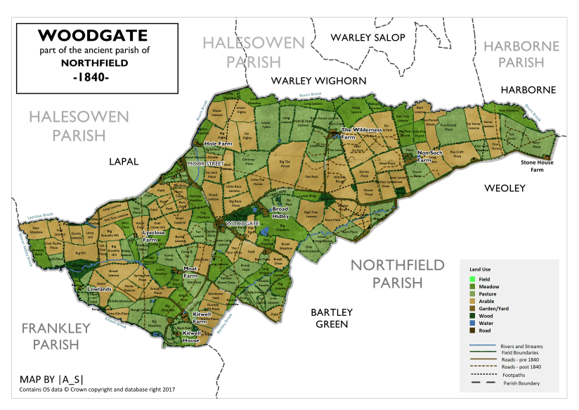
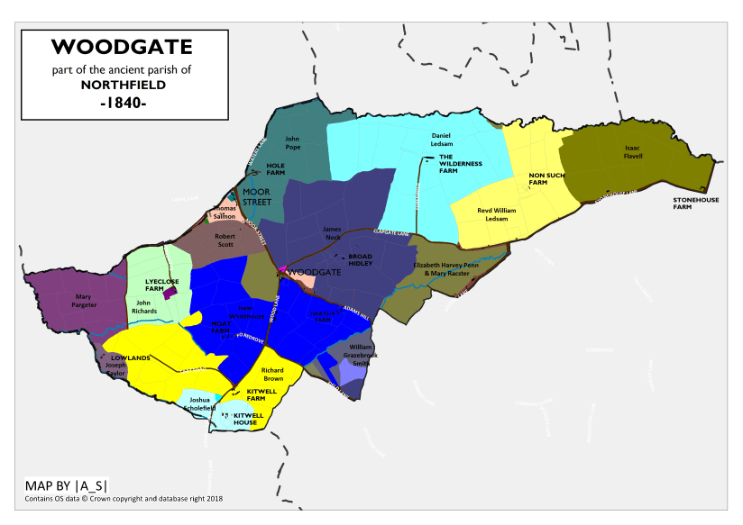
Before becoming part of the city of Birmingham in 1911 Woodgate used to lie within the far western part of the ancient parish of Northfield in the county of Worcestershire.
Woodgate was bounded by the following areas:
- To the west by Lapal, in the ancient parish of Halesowen, which since Norman times, had been a detached part of Shropshire, until it was transferred to Worcestershire in 1844.
- To the north by the township of Warley Wighorn in Worcestershire – which, like Lapal, was also in the parish of Halesowen, but confusingly was never part of Shropshire.
- To the north-east by the parish of Harborne in Staffordshire.
- To the south-west by the parish of Frankley in Worcestershire
- To the south east by the remainder of the parish of Northfield including the areas of Bartley Green, Weoley, Northfield village and Selly Oak.

The boundaries which I’ve used for the map of Woodgate are as follows:
For the most part the map boundary follows the historic parish boundary of Northfield:
Starting at the southernmost point, going clockwise, the boundary runs along the northern extent of a large wood shown on the 1840 map, south of the grounds of Kitwell House. From here moving west the boundary crosses a pool, and then followed the course of the Kitwell Brook to the south of Lowlands Farm, where it joins Manor Abbey Brook.
The boundary then follows Manor Abbey Brook northwards to the far western tip of the parish where it is joined by Lyeclose Brook. The boundary takes a right-angled turn east and follows Lyeclose Brook, and then a small tributary, Raddens Brook before then following Lye Close Lane. The boundary crosses the crossroads with Moor Street/ Carter’s Lane and then follows Watery Lane northwards. The boundary then follows the course of the Bourn Brook eastwards until it reaches Northfield Road.
From here the parish boundary continues along the brook, but here our Woodgate map boundary diverges and follows Northfield Road southwards, and then turns westwards along Stonehouse Lane. The boundary then turns south along Jiggin’s Lane for a while before turning north up a trackway before following the former boundary of Juggin’s Wood. The boundary then follows the edge of the estates belonging to the late William Grazebrook before turning northwards along Field Lane. The boundary then follows the course of the Bartley Brook, back to Kitwell House.
Woodgate before 1840
Though the earliest detailed maps of the area date from the early 19th century, there are numerous other clues to the history of Woodgate before this time.
It’s likely that the Bourn Brook has long since been of great local importance, and it also forms an important landmark – marking the ancient county boundary between Worcestershire, Staffordshire and Warwickshire.
Bronze Age Remains
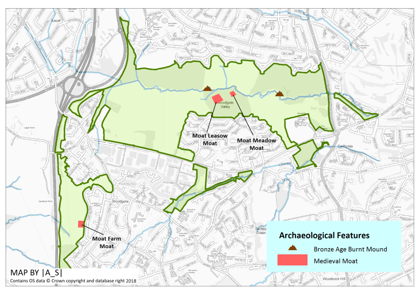
The earliest evidence of human activity in this area comes from the Bronze Age with the presence of two burnt mounds recorded next to the Bourn Brook, one of which, near to The Wilderness Farm, has been radiocarbon-dated to about 2020 BC . In addition part of a bronze flat axe blade, thought to date from from 2000 BC-600 BC was also discovered near Stonehouse Road¹.
Medieval Moats
The rich and productive soil of the meadows either side of the Bourn Brook would have been important and the landscape here is known to have been farmed since at least medieval times.
Evidence of human settlement in and around Woodgate at this time includes three potentially medieval moated sites including a moat associated with the former Moat Farm².
In addition, just south of the Bourn Brook, in Moat Meadow, it is thought that there would have been an extensive moat system, surrounding wooden farm buildings. The remains of the moat are still visible today, particularly in wet weather when it forms a pond. It’s thought that the moats in the Woodgate area date from the 12th and 13th centuries³.
Salt Road
It’s believed that Watery Lane, formed part of an ancient route taking salt from Wales to Lincolnshire. The hedgerow along the lane has been dated to around 1270.
There is also a historic cart track, close to the Visitor Centre, which is thought to be about 500 years old and was once the main east to west road for the area³.
Canals
Though farming still dominated the landscape up to 1840, already there had been the first signs of the industry which was to later transform parts of the area. In 1798 the 3.4 km long Lapal Tunnel, which helped to connect the Dudley No. 2 canal in Lapal to the Birmingham and Worcester Canal at Selly Oak was opened.
Though the tunnel went underneath Woodgate Valley, there were still some traces on the surface including spoil heaps along the route of the canal, and an air hole, which was in a field known in 1840 as Chimney Piece. Some of the spoil heaps are still visible.
Constructing such a long tunnel was clearly an (over?)ambitious project, and over the years the tunnel suffered from a number of collapses before being eventually abandoned in 1917.
Woodlands
Woodgate and the surrounding area would have relatively-well wooded in comparison to other parts of Birmingham. The 1840 map shows some quite large areas of woodland and earlier maps, such as the 1822 map of Worcestershire, and field names give additional clues to woodlands which would have been cleared just before his time.
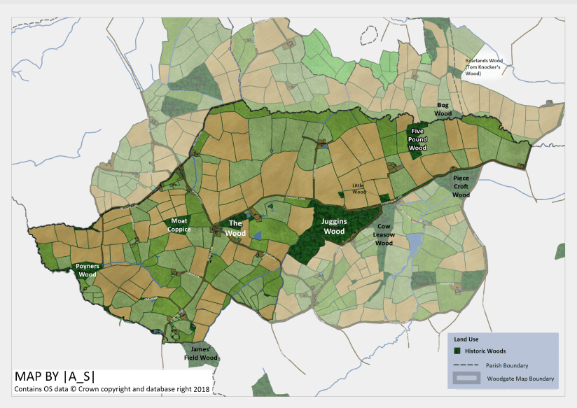
The Wood (Broadhidley Wood)
This wood lay south of Clapgate Lane and formed part of the Broadhidley Farm Estate. The woodland stood just to the west of the farm house and to the east of the hamlet of Woodgate. To the east of the wood was an orchard and pond.
Part of the wood still exists, though the eastern section of it is thought to have been partly disturbed/cleared and has subsequently regenerated. The wood was described in a site survey report in 2007 as being dominated by mature oak with some ash and beech. The presence of boundary earthworks and remnants of boundary hedgerows also suggests the woodland is quite old, though the even age of the oak trees suggested they may be of planted origin⁴.
Juggins Wood
This was a large wood situated south west of the junction of Clapgate Land and Jiggins Lane along the valley of the Bartley Brook.
The former extent of the wood is shown on the Worcestershire map of 1822 but by 1840 most of the woodland had been cleared and converted to pastures and arable land while only a tiny section (the north west corner) remained.
This remaining section of woodland still exists and now forms part of Woodgate Valley Country Park.
In a report from 1989 it was described as a small but attractive remnant of an oak woodland, formerly much larger in extent. Although none of the trees are old, they are mature and the site with its old boundary bank retains the character of an ancient woodland⁵.
Cow Leasow Wood
Adjacent to Juggins Wood on the other side of Jiggins Lane and just outside our map boundary was Cow Leasow Wood, which was a rather long narrow woodland stretching southwards towards a footpath running between Genners Lane and Connops Mill.
The wood still existed in 1840 and formed part of the Sinnelleys Estate. By the 1880’s the woodland had been cleared, though some boundary trees may still survive along the western boundary of Sennelleys Park.
Little Wood
Little Wood was, unsurprisingly, a rather small 0.4 hectare wood which stood to the north of Clapgate Lane opposite its junction with Jiggins Lane. It formed part of the Nonsuch Farm Estate. It is recorded on the 1840 tithe map but by the 1880s it had been cleared. It’s now the location of the houses of Stonehouse Grove.
Five Pound Wood
Five Pound Wood stood just south of the Bourn Brook, to the north east of Nonsuch Farm. It is shown on the Worcestershire map of 1822 but by 1840 it had been cleared to make way for arable land, though it’s name lived on in the name of the field. Some of the outer boundary trees of the wood may still survive as ‘assart’ woodland.
Bog Wood
Bog Wood stood just to the north of the Bourn Brook near to the boundary between Warley Wighorn and Harborne. The wood formed part of the Mopbeggar Farm Estate. The wood is shown on maps from the 1880s but it seems that the woodland had been cleared by the early 1900s though some of the boundary trees, particularly those along the brook, may have survived.
Piece Croft Wood
Piece Croft Wood was a triangular wood which stood west of the junction between Stonehouse Lane and Barnes Hill. It is shown on the Worcestershire map of 1822 but by 1840 it had been cleared to make way for meadowland, though it’s name lived on in the name of the meadow. By the 1880s a large clay pit had been constructed on the land.
Moat Coppice
Moat Coppice is the name of an arable field on the 1840 map. It formed part of Moat Farm. Though it isn’t depicted as woodland on the older maps (1814, 1822) the field name suggests that it might have been woodland historically. Part of the field is now part of Woodgate Valley Country Park and a small section of boundary hedge may contain remnant trees from the former wood.
Poyners Wood (Coopers Wood)
Poyners Wood stood either side of a tributary of Manor Abbey Brook. In 1840 it formed part of land owned by Mary Pargeter but was occupied by Richard Cooper (perhaps the source of the later name that the wood was known by the 1880s?).
Poyners Wood still exists today and is described as a mature alder and oak dominated woodland⁷.
James’ Field Wood
Just outside our map boundary in the neighboring parish of Frankley stood James’ Field Wood. It is shown on the 1840 map but by the 1880s it had been cleared, though some of the boundary trees may survive.
Bearsland Wood (Tom Knocker’s Wood) (Harborne)

Though it lies a bit further outside our map boundary situated just south of the (modern day) junction of Quinton Road West and West Boulevard, a notable mention must go to Bearsland Wood, which was also known rather intriguingly as Tom Knockers Wood.
It is shown on an 1834 map of Harborne (named as Tom Knocker’s Wood) and was depicted in an 1878 painting by Charles Thomas Burt. It was clearly an important local landmark.
It seems that at least part of the wood existed up to the 1950’s.
Rivers, Streams and Mills
Woodgate spans two of the great river watersheds of Great Britain – the Severn and the Humber.
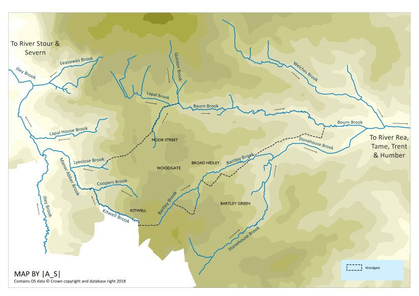
The west of the area drains westwards towards the Illey Brook via Kitwell Brook, Coopers Brook, Lyeclose Brook and Manor Abbey Brook. The Illey Brook then feeds the River Stour, which flows south west to eventually join the River Severn at Stourport. The Severn then flows into the Bristol Channel.
The eastern site of Woodgate drains eastwards towards the Bourn Brook, via Stonehouse Brook, Bartley Brook, Lapal Brook and Quinton Brook. The Bourn Brook then flows into the River Rea at Selly Park. The Rea then flows northwards through Birmingham City Centre before joining the River Tame. The River Tame then flows into the River Trent near Alrewas, Staffordshire. The Trent then joins the River Ouse at Trent Falls to form the Humber Estuary which flows into the North Sea.
Wood Lane, Moor Street and Carters Lane runs roughly along the top of the ridge that separates the two catchments.
Woodgate in 1840
Woodgate in 1840 was still predominantly a rural landscape comprised of scattered farm estates with a mixture of meadows, pastures and arable land.
Roads and trackways
By 1840 the following roads were already in existence:
| Present Day Name | Tithe Map Name (1840) | Other Names |
| Adam’s Hill (1920’s?) | Wood Gate | |
| Clapgate Lane | Clapgate Lane | |
| Field Lane | Field Lane | |
| Jiggins Lane | Juggins’s Lane | |
| Kitwell Lane | Kitwell Lane | |
| Lyeclose Lane | Lyeclose Lane | |
| Northfield Road | Northfield Road | |
| Stonehouse Lane | Peascroft Lane | |
| Watery Lane | Watery Lane | |
| Woodgate Lane (1912) | Moor Street |
In 1840 the following roads/tracks existed but in the present day still exist only as unnamed tracks:
- An old cart road leading off from Kitwell Lane Towards the direction of Lowlands Farm
- A trackway leading west from Lyeclose Farm before forking south towards Cooper’s Wood (Poyners Wood and north towards Lapal Lane.
In 1840 the following roads/tracks existed but in the present day no longer exist:
- Foredrove to The Wilderness Farm (now the approximate location of Somerfield Road) – a small section still remains to the right between two hedgerows (M. Surman pers, coms)
Settlements
Woodgate

The settlement of Woodgate stood at a crossroads of Adams Hill /Moor Street and Wood Lane/Clapgate Lane. Moor Street is thought to have formed part of a turnpike road that linked to Northfield and onward to Lapal via Carters Lane⁸.
To the east of the crossroads stood a sizeable woodland belonging to the large historic Broadhidley Estate, while the land to the east of the crossroads was owned by Elizabeth Harvey Penn and Mary Racster.
Around the junction of the crossroads were a cluster of cottages and shops.
On the western side of the crossroads stood a pub known as The White Horse. The pub is not specifically named on the 1840 map, but the building is shown and at the time and described as “Three Houses & Gardens” it was owned by Elizabeth Harvey Penn and Mary Racster.
It’s labelled on the 1884 map. By the 1950’s it seems that the pub had been converted into houses, and by the 1960s the building had been demolished.
Opposite the pub on the other side of Wood Lane stood 5 houses owned by Elizabeth Wakeman.
To the north of thee buildings, directly next to Adams Hill (then known as “Wood Gate”), was what appears to be a long pond.
Further down Adams Hill were two cottages occupied by Daniel and William Walker and a house and shop owned and occupied by James Nock, the owner of the Broadhidley Estate.
Closer to the crossroads, backing onto the wood was a cottage and shop owned by Thomas Salmon, but occupied by William Heath. It’s possible that this building may still stand today (?).

To the north of the crossroads, between Clapgate Lane and Moor Street stood three houses owned by Elizabeth Bate and occupied by Benjamin Field, Thomas Brooks and James Smith.
The centre of Woodgate didn’t see significant change until the 1960’s but it’s likely that many of the old houses/cottages were demolished about this time to make way for the development of the area.
Moor Street

To the north of Woodgate, further up Moor Street (now Woodgate Lane) stood the hamlet of Moor Street. Like Woodgate, this settlement also stood on a crossroads – this time Moor Street/Carters Lane and Lye Close Lane/Watery Lane – the latter marking the historic parish boundary between Northfield and Halesowen.
Lye Close Lane and Carters Lane led to Lapal and Halesowen, while Moor Street formed part of the turnpike road leading to Bartley Green and Northfield. Watery Lane led to Hole Farm and then northwards to Ridgeacre.
To the north of the cross roads stood the Crown Inn, which was listed in 1840 as belonging to Benjamin Cooper. By the 1880s the pub had become known as the Old Crown, which still stands at this location.
To the south of Lye Close Lane stood a row of cottages:
The first house and shop on the corner was owned by Thomas Robinson and occupied by Thomas Green. Next were two cottages owned by Edward Grove, one of which was occupied by Richard Fisher. Next to this was a cottage and shop also owned by Edward Grove, but occupied by Josiah Moore, followed by two further cottages, one of which was occupied by Joseph Ingram. Next were two cottages owned by Thomas Salmon who also owned the fields behind the cottages to the west. These two old cottages appear to still exist today.

The cottages were occupied by Joseph Fallows and Thomas Powell. Finally in this row were two cottages owned by Theodore Price occupied by Mark Andrews and John Andrews.
To the west of the cottages in the middle of Birchley Close stood a house and orchard belonging to Thomas Salmon and occupied by Thomas Sargent.
There was also a scattering of cottages along Lye Close Lane – the first of which stood at the junction with Lapal Lane. This house was owned by James Bissell and it was occupied by Joseph Rudge and George Holloway. Interestingly the field behind the house was known as Rudge’s Leasow.
Further along the lane were a small cluster of three cottages, with the cottage to the north owned by Susan Rose, while the two cottages opposite were owned by Thomas Salmon, and occupied by Ann Field and Edward Field.
To the east of the hamlet was farmland forming part of the Hole Farm estate.
Farms and Estates
Broadhidley (Broad Hidley)
Broadhidley is first mentioned in the 13th century (BGDH) and Hole Farm and Wilderness Farm once formed part of the estate, though by 1795 they were considered as separate.
Broadhidley Hall Farm lay to the north east of the hamlet of Woodgate and was bordered to the north by Hole Farm and Wilderness Farm and to the south by Adam’s Hill. The boundary between Broadhidley and the farms to the north was marked by an ancient cart track.
Clapgate Lane, separates the estate in two, and it’s thought that the lane was originally created to act as a trackway to the farm.
The farmhouse stood just south of Clapgate Lane just east of a block of woodland (see The Wood (Broadhidley Wood) above).
In 1840 the Broadhidley Estate was owned and occupied by James Nock.
In the 1936 Birmetals was built on part of the farmland which would have drastically altered the character of the area. Clapgate Lane was also re-routed and widened.
The farm buildings survived until sometime in the late 1970s/early 80s when they were demolished and replaced by houses (Bartley Woods).
The northern part of the farmland became part of Woodgate Valley Country Park, and some of the old field boundaries still survive.
Hole Farm
Hole Farm originally formed part of the Broadhidley Estate. It is first mentioned in 1344 (BCC), though the hedges along Watery Lane, which leads to the farm have been dated to at least 1270.
Hole Farm was bordered by Watery Lane to the west, Bourn Brook to the north, Wilderness Farm to the East, and Broadhidley Farm to the south. The farmhouse was located just off Watery Lane, and the farm buildings still exist as the Hole Farm Trekking Centre.
In 1840 the farm was owned by John Pope and occupied by Benjamin Cutler.
Some of the fields are named “Higley” – Big Higley, Far Higley and Lower Higley. This may possibly have originally have been “Hidley” – making reference to fact that the farm was historically part of the Broadhidley Estate.
Clapgate Lane was rerouted through the southern part of the farm in 1936 when Birmetals was built.
The majority of the farmland became part of Woodgate Valley Country Park, and some of the old field boundaries still survive.
The Wilderness Farm (Moor Farm)
Wilderness Farm, along with Hole Farm, originally formed part of the Broadhidley Estate.
The farm lay to the west of Hole Farm and was bordered to the north by the Bourn Brook. Nonsuch Farm lay to the west and to the north was Clapgate Lane.
The farmhouse stood at the end of a long foredrove (driveway) extending due north from Clapgate Lane roughly at the modern day junction with Somerfield Road. The farmhouse was situated just north of where Tibbatts Close is today.
In 1840 the farm was owned and occupied by Daniel Ledsam, a London Merchant who in 1809 had also bought Northfield Manor House.
Two of the fields – Moat Leasow and Moat Meadow contain features which are thought to be the remains of a medieval moat system. This may mark a previous location of the farm buildings.
One of the fields is called Lower Tylers – possibly indicating the historic site of a tile kiln.
By the 1880’s the farm is now named Moor Farm.
In around 1970 the farm buildings were demolished and the Somerfield Road housing estate was built on part of the farmland. The remaining part of the farm became part of the Woodgate Valley Country Park.
Nonsuch Farm
Nonsuch Farm has been described as the oldest farm in this area (BGDC). The farm was bordered to the west by Wilderness Farm, to the north by the Bourn Brook, to the east by Stonehouse Farm and to the south by Stonehouse Lane.
The farmhouse stood at the location of the modern day Gravel Bank and legend has it that King Charles II hid in the barn when being chased by the Royalists (BGDC).
In 1840 the farm was owned by the Reverend William Ledsam (presumably a relation of Daniel?) and occupied by Catherine Childe.
Development of the farm began with the construction of houses along Stonehouse Lane in the 1950s/60s followed by the construction of the Somerfield Road estate in the 1970s.
The north eastern part of the farmland became part of Woodgate Valley Country Park.
At one time the land was used by the RSPCA for sick and retired horses.
Stonehouse Farm
Stonehouse Farm is thought to be so-named because the farmhouse was constructed using stones from the ruins of the nearby Weoley Castle – at a time when most houses would have been made from timber.
Stonehouse Farm was bordered by Nonsuch Farm to the west, Bourn Brook to the north and Stonehouse Lane. The farmhouse stood at the junction of Stonehouse Lane and Northfield Road.
In the early 1840s the farm was bought by Isaac Flavell, who was born in Gornall in 1792 and had made his fortune in America¹.
He soon set up a brick and tile making business on the land and initially lived in the farm house, moving to the California Inn by 1851. He also owned a canal wharf in Gas Street. He died in 1870 but brickmaking at this site continued – following Isaac’s death the enterprise was acquired by William Smart who set about expanding the business⁶.
The later 1880s map show a brick and tile works located off Stonehouse Lane in the grounds of the modern day Hillcrest School. The tile works included a claypit and several kilns.
A second larger claypit was located where the Fire Station now stands which linked to the main brickworks building located north of the canal just east of Barnes Hill.
Also, by the 1880s to the north of the two claypits stood a house called Coalpit House, with a pumping engine and an old coal shaft, which is said to have been sunk by Isaac Flavell in the 1840s to provide coal for the Brick and Tile Works. It appears that the shaft had to be abandoned due to influx of water².
The Brick and Tile Works appears to have been active until the 1950s/60s at which point Bartley Green Grammar School for Girls was built.
It appears that the old farmhouse survived until at least the 1920s, and by the 1960s a pub called The Stonehouse is standing just to the north of this location.
The northern section of the farm became part of Woodgate Valley Country Park.
Kitwell House
Kitwell House stood off Kitwell Lane south of Bucknall Close. It is thought that the house took its name from a chalybeate spring, Kitt’s Well, which was located on the west side of Kitwell Lane¹.
Such springs had a spiritual significance from the earliest times and may have been used for baptisms.
The house accessed via a driveway from Kitwell Lane and was surrounded by pasture and an orchard. Also forming part of it’s grounds were a large pasture plus woodland and pool located west of Kitwell Lane. By 1884 it appears that the pool was dry.
The house has had a number of notable residents. Jane Loudon, nee Webb, lived at Kitwell House with her father until her marriage in 1830. She was most well known for her series of horticultural books for ladies. A blue plaque on the wall of Kitwell School in Wychbury Road commemorates her connection to the area.
By 1840 the house owned and occupied by Joshua Scholefield, a successful iron manufacturer, merchant and banker. He was elected as one of Birmingham’s two first members of parliament in 1832.
He died in 1844 at the age of 69 and was buried in Edgbaston churchyard.
The house had been demolished by the 1970’s and Kitwell Substation was built here.
Kitwell Farm
Kitwell Farm was situated north of Kitwell House, and was bounded to the north by Field Lane and Cooper’s Brook.
The farmhouse was located off Kitwell Lane, roughly where Bucknall Crescent is today. In 1840 the farm was owned by Richard Brown and occupied by James Worsey.
The farmhouse was demolished in the 1960s to make way for housing, though the western part of the farmland still exists and the section east of the M5 Motorway now forms part of Woodgate Valley Country Park, while the section to the west of the M5 is still farmland.
Moat Farm
Moat Farm lay to the west of Kitwell Lane and was bounded by Kitwell Farm to the south and Lyeclose Farm to the west. The farmhouse stood at the end of a driveway opposite the junction of Kitwell lane and Field Lane. The farmhouse was surrounded by the remnants of an old moat – indicating the farm was likely to be of medieval origin.
In 1840 the farm was owned and occupied by Isaac Whitehouse, who also owned the adjacent Heathy Farm.
The 1980s saw the construction of housing off Pinewood Drive and Clent View Road.
The farmhouse appears to have survived at least until the early 1980s, but it has since been demolished.
The remaining farmland became part of Woodgate Valley Country Park.
Heathy Farm
To the east of Wood Lane, to the south of Woodgate hamlet was Heathy Farm, which was also owned by Isaac Whitehouse.
The farmhouse stood just off Adams Hill (then “Wood Gate”), where Lutley Grove is today.
Heathy Farm was developed for housing in the 1960s.
Lowlands
Lowlands was a small estate lying to the extreme south west of Northfield parish bordered to the south by Kitwell Brook.
Farm buildings stood to the east of the brook.
In 1840 owned by Joseph Taylor and occupied by Benjamin Connop
The farmland still exists but the farm buildings had been demolished by the 1960s.
Lyeclose Farm
Lyeclose Farm stood south of Lyeclose Lane and was bounded to the west by farmland owned by Mary Pargeter, to the east by Moat Farm and to the south by Kitwell Farm.
In 1840 the farm House was owned and occupied by James Field, while surrounding farmland was owned by John Richards and occupied by John Connop.
The farmhouse still stands at the end of a long driveway off Lyeclose Lane.
Further Reading
Much of this article was written with the help of the research of Bartley Green District History Group. If you would like to read more about the history of Woodgate and Bartley Green then their website is invaluable.
Kings Norton Parish:
Brandwood End | Stirchley | Cotteridge | Haunch Heath | Kings Heath | Balsall Heath | Moseley
¹ Dargue, W (2018) A History of Birmingham Places and Place Names from A to Y – link
² Halstead, J (1989) Woodgate Valley: A Preliminary Field Survey and Desktop Assessment
³ Birmigham City Council (2018) History of Woodgate Valley – link
⁴ Atkinson, S (2007) Broadhidley Wood – Local Site Assessment. The Wildlife Trust for Birmingham and the Black Country
⁵ Woodgate Valley – SINC Citation
⁶ Birmingham History Forum (2008) California Inn – link
⁷ McKay, E (1998) Cooper’s Wood & Lyleclose Meadow – Local Site Assessment
⁸ Bartley Green District History Group – link
