
Before becoming part of the city of Birmingham in 1911 the area around Haunch Lane used to be part of Kings Norton Parish in the county of Worcestershire. Kings Norton Parish was divided into different Yields for tax reasons and Haunch Heath was in the Moseley Yield along with Moseley, Balsall Heath and Kings Heath.
For the purposes of this map Haunch Heath is defined as the area bounded by the Turnpike Road (now Alcester Road South) to the west, Chinn Brook to the south, Haunch Brook to the east and Wheelers Lane to the north. The reason that I have created a separate map for Haunch Heath (from the rest of modern day Billesley to the east) is that the majority of Billesley was in the separate parish of Yardley in 1838, with the Haunch Brook forming the ancient parish boundary.
Haunch Heath before 1838
The northern part of the map area existed as open, unenclosed heath, common or ‘waste’ until the series of enclosure acts in the 1700’s led to this land being parcelled off and brought under agricultural use. The land to the west of Haunch Lane was part of the larger ‘Kings Heath’ which extended northwards and covered much of modern day Kings Heath. This land was enclosed in 1772. The area to the east of Haunch Lane was known as ‘Haunch Heath’ and is thought to have been enclosed prior to this date. The older, possibly ancient areas of farmland are in the south of this map.
The name ‘Haunch’ is thought to come from the medieval word for the hip, buttock, and thigh of an animal (usually a cow, pig etc) which the the shape of the land at Haunch Lane was said to resemble.
Haunch Heath in 1838
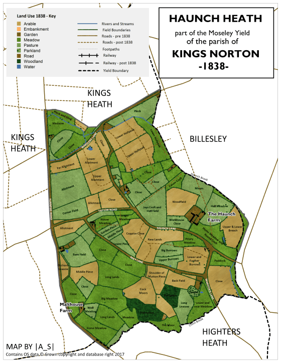
In 1838 Haunch Heath was an almost entirely rural area with two large farms and a couple of other smaller farm holdings. The land use at this time was a patchwork of arable, pasture and meadowland. The area was nestled between two brooks, the smaller Haunch Brook (or Haunch Ditch) and the bigger Chinn Brook which flows eastward into the River Cole.
By 1838 the following roads were already in existence:
| Present Day Name | Tithe Map Name (1838) | Other Names |
| Alcester Road South | Alcester Turnpike Road | |
| Haunch Lane | Haunch Lane | |
| May Lane | May House Lane | |
| Taylor Road | Road | |
| Warstock Lane | Road | |
| Wheelers Lane | Road |
The Haunch Farm
The Haunch Farm was built on the recently-enclosed heath and, by 1838, was owned by one of the largest landowners of the parish, James Taylor (soon to become Tory MP for East Worcestershire in 1841), who resided in Moseley Hall and owned large tracts of Moseley, Kings Heath and Haunch Heath.

In 1838 The Haunch Farm, which lay on both sides of Haunch Lane, was occupied by Thomas Avery and along with the farm building itself there was recorded a malthouse, yards, orchard and garden. The farm buildings themselves lasted until around 19601 though part of the farmland survived the housing development from the 1930’s onwards and is now the southern part of the modern day Billesley Common and Cocks Moors BMX track.
Further north along Haunch Lane was more farmland, again owned by James Taylor, but occupied by Thomas Lawler, a house, shop, stable and garden owned and occupied by William Guest, and a house and garden owned by Thomas Gough.
On the corner of Haunch Lane and Wheelers Lane was a house and pasture owned and occupied by Catherine Wheeler (the source of the road name?).
Nestled in the junction of May Lane and Taylor Road was a smaller farm owned by Robert Cottrill and occupied by Mark Taylor.
North of Taylor Road were small pieces of farmland owned (going from south to north) by Trustees of the late John Brittle, Mary Edwards and the Rev. Vincent Edwards and William Cudd.
North of Wheelers Lane, nestled between two small brooks was further farmland owned by James Taylor, including a house, cowhouse and garden off the Turnpike Road occupied by Abraham Hollyoake.
Malthouse Farm
The landscapes south of May Lane were much older, and Malthouse Farm, then owned by James Taylor and occupied by Thomas Wheeldon is thought to be of Elizabethan origin. The farm building still survives today, though converted to housing and is described as:
“a sympathetically refurbished Grade 2 listed farmhouse in courtyard setting. Dating from early 16th century with Victorian additions. Fully modernised whilst retaining many period features”. ³

To north of this and just south of Taylor Road there was another small farm occupied by Ann Crathorn.
Cocks Moors
To the east of Malthouse Farm, in the valley of the Chinn Brook, is land which is now the current day Cocks Moors Golf Course, which reatains a couple of features of the former rural landscape, most significantly two blocks of woodland known as Cocks Moor Woods. These woods, which are shown on the 1838 map, contain a number of features which are associated with ancient woodland such as boundary banks and ditches along with ancient woodland species such as Bluebell, Wood Anenome, Ramsons (aka Wild Garlic), Wood Melick and Lesser Celandine. ⁴
Further Reading
Some of this article was written with the help of the research of Kings Heath Local History Society. If you would like to read more about the history of Kings Heath then their website if invaluable.
Other Parts of Kings Norton Parish:
Brandwood End | Stirchley | Cotteridge | Kings Heath
1. William Dargue – A History of Birmingham Places and Place Names from A to Y – Haunch Heath https://billdargue.jimdo.com/placenames-gazetteer-a-to-y/places-h/haunch-heath/
2. Moseley Society – Moseley Hall https://moseley-society.org.uk/wp-content/uploads/2015/02/Moseley-Hall.pdf
3. Malthouse Farm on Mouseprice https://www.mouseprice.com/property-for-sale/ref-17727735/the+farmhouse+malt+house+farm+456+alce+b14+ for photo see http://www.rightmove.co.uk/property-for-sale/property-28126021.html
4. The Wildlife Trust for Birmingham and Black Country (2005) Cocks Moors Woods Local Site Survey

Is there a historical recollection by any person of a Haunch Hall situated in the area ,poss kings Norton around 1648 owned by a Mary Ford ,I believe was the grandmother of the lexicographer Samuel Johnson
LikeLike
Brilliant! Is there a print version of the areas you have researched around Alcester Lanes End? I’d love to buy them as a complete book.
LikeLiked by 1 person
Not currently!
LikeLike