Before becoming part of the city of Birmingham in 1911 Cotteridge used to be part of Kings Norton Parish in the county of Worcestershire. Kings Norton Parish was divided into different Yields for tax reasons and Cotteridge was mostly in the Moundsley Yield along with Stirchley, Kings Norton, Walkers Heath, Monyhull and Highters Heath.
The boundaries which I’ve used for the map of Cotteridge are as follows: the north and western boundaries of Cotteridge are defined by the ancient parish boundary between Kings Norton and Northfield. This boundary is marked by first The Bourn brook, and then, going clockwise, Selly Oak Road and then Northfield Road. The boundary then follows the newly constructed Birmingham and Gloucester Railway to the south and then more-or less the Birmingham and Worcester Canal northwards until it meets The Bourn brook once again.
Cotteridge before 1838
The name ‘Cotteridge’ is thought to derive from the ridge of higher ground along which an ancient trackway ran (now Northfield Road).
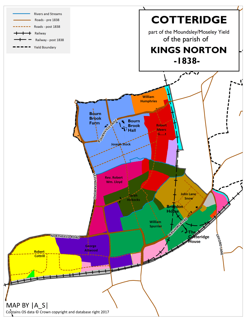
Cotteridge in 1838
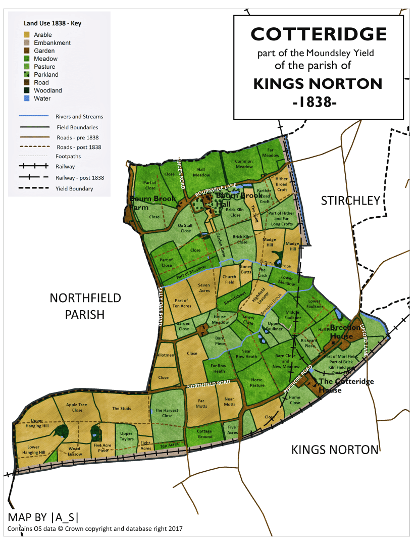
At the time of the 1838 tithe map Cotteridge had no centralised settlement as such and was instead thoroughly rural, with a scattering of farms and estates. Land use was a mixture of meadows, particularly in the brook valleys, pastures and arable land, which was more prevalent on the higher ground to the west.
There were three brooks flowing west to east towards the River Rea, including Cotteridge Brook, Breedon Brook and to the north, The Bourn, which was the larger of the three.
By 1838 the following roads were already in existence:
| Present Day Name | Tithe Map Name (1838) | Other Names |
| Bournville Lane | Road | |
| Franklin Road (part) | Road | |
| Lifford Lane | Road | |
| Linden Road | Road | |
| Northfield Road | Road | |
| Pershore Road | Turnpike Road | |
| Selly Oak Road | Road | |
| Station Road | Road |
The Cotteridge House
A notable estate at this time was The Cotteridge House, which stretched from the railway northwards to the Breedon Brook, was then owned by William Spurrier who was a silver roller by trade. The farm was rented by William Martin. The Cotteridge House, along with farm buildings, yards an orchard and garden, stood just off the Pershore Road and is thought to have dated from at least 1680. By 1904 the house had been demolished to make way for housing.
Breedon House
Further up Pershore Road located on the opposite side of the road stood Breedon House which was owned and occupied by John Lane Snow. By 1904 this farm too had been developed for housing.
The area around the junction of Lifford Lane and Pershore Road was known as Breedon Cross.
Other Farms
Between the two small brooks was a farm (unnamed on the map), owned by Sarah Hickocks and then occupied by Henry Chinn. The farm buildings were located off the modern day Franklin Road and included two tenements, a barn, stable, cowhouse and garden.
North of this was farmland owned by Reverend Robert William Lloyd which was also rented to Henry Chinn. Given the ecumenical nature of its owner, one of the fields was aptly named Church Field.
North east of here was part of the estate of Robert Meers Guest who owned Leys Farm, to the east of the canal in Stirchley. The farmland was tenanted by George Cotterill.
A small part of the farmland in this area still survives as open land in the name of Cotteridge Park, indeed some of the trees in the park may be remnants of the old farm hedges.
Bourn Brook Hall and Bourn Brook Farm
In 1838 Bournville didn’t exist. Even the name ‘Bournville’ is thought to be a 19th century invention. Instead in this area, either side of the road now known as Bournville Lane, stood Bourn Brook Hall and Bourn Brook Farm.
The hall was thought to have been built in the early 1800’s and originally belonged to the Izon family before being bought by Richard Stock, a glass and lead merchant, who owned and was occupier of the hall and farm in 1838. Associated with the hall were offices, two tenements, yards, gardens and woodland.
The hall was demolished in 1907 and its former grounds now form part of Bournville Park.
The farmhouse, located on the corner of Bournville Lane and Linden Road later became a cider house known as The Old Farm Inn and is now the present day Old Farm Hotel.
The modern day chocolate factory was built in 1879 on farmland previously owned by William Humphries, who also owned Bournbrook Cottage plus a stable, cowhouse and garden located north of Bournville Lane.
Further Reading
There is a nice history of Cotteridge on the Cotteridge.com website

4 thoughts on “Cotteridge, 1838”