
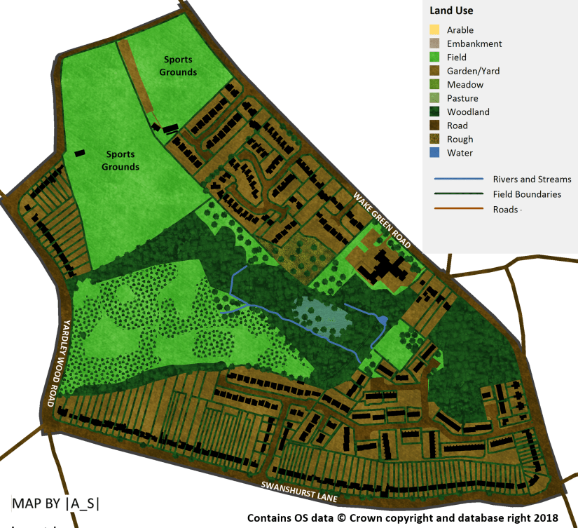
Although we now know the area of woodland, wetland and meadows that lie between Yardley Wood Road, Windermere Road and Swanshurst Lane as Moseley Bog, this is actually a relatively recent name for this site. For the sake of both brevity and clarity throughout this article I will refer to the site as ‘Moseley Bog’ even if it wasn’t known as this at the time.
Incidentally it is believed that there was once another botanically-rich area known as ‘Moseley Bog’ somewhere nearby but the exact location of this site is not known. A map of the Taylor Estate from 1807 does depict an area called ‘The Bog’ located east of Billesley Farm (now the location of Trittiford Road/Eastham Road/Purefoy Road.
Early History
There is evidence of man’s presence in Moseley Bog dating back to the Bronze Age, through the presence of burnt mounds near to the brook. At this time the area would have been part of the pre-historic ‘wild wood’ but by the time of the Domesday survey in 1086 much of the woodland had been cleared.
The Coldbath Brook, which rises near the top of Cambridge Road in Kings Heath flows through Moseley Bog before before joining the River Cole.
Either side of this brook would have been meadowland sandwiched, to the north and south, by two large expanses of common land (or waste) – Moseley Wake Green, which extended northwards to the present day Woodlands Road and the smaller Swanshurst Common which extended southwards before becoming known as Billesley Common south of the lake in present day Swanshurst Park. This common land would have been mainly used by local people (commoners) for grazing animals, and in some places possibly for open field strip farming.
The earliest mention of Swanshurst Common is 1577 when the land was described as waste.
Along the Coldbath Brook were located four mill pools. These would have been constructed artificially, possibly by enlarging existing natural ponds. The first and largest of the pools was known as Coldbath Pool and it is still located within the modern day Moseley Golf Course – though it is now reduced in size. Coldbath Pool, which dates from at least 1750 is thought to have been constructed as a fish pond¹.
Almost immediately downstream from this pool was the smaller Lady Mill Pond, with the course of Stoney Lane (later known as Yardley Wood Road) running along the length of its dam.
These pools were associated with a mill which stood on the eastern side of Stoney Lane. This mill had many names over the years, first mentioned in 1437, when it was known as Greethurst Mill when it formed part of the ancient Greethurst Estate which is first recorded in 1221² and was centred around Bulley Hall³ which was located near the junction of Springfield Road and Brook Lane. The mill (or perhaps a newer mill in a similar location) was later known as Holte’s Mill, Coldbath Mill and then Lady Mill. At one time the mill operated as a thread mill and then later as a wire-drawing mill. The name Lady Mill may suggest that it’s revenues were given for the service of Our Lady, presumably for the Chapel of St. Mary in Moseley⁴.
In the 16th century Lady Mill and surrounding land was owned by the Grevis family of Moseley Hall who built up land holdings in the area over time. The Grevis family went through a period of financial decline and as a result the estate was sold in 1764 to John Taylor of Bordesley Park, a wealthy button manufacturer, who bought the Moseley Hall estate for his son John Taylor II.
The third pool along Coldbath Brook was known variously as Old Pool (1807), Great Pool (1843) and Dell Pool (date unknown) and is thought to have been constructed in the 16th century. This pool acted as a secondary pool for Sarehole Mill and was within the present day Moseley Bog.
Sarehole Mill Pond, which still exists today, is situated east of Wake Green Road next to Sarehole Mill Museum.
Sarehole Mill is thought to have been in existence before the reformation and was rebuilt in 1542. Until 1768 it was fed by only the water from the Coldbath Brook but after this date a leat was dug from the River Cole to provide additional water.
Moseley Bog in 1770
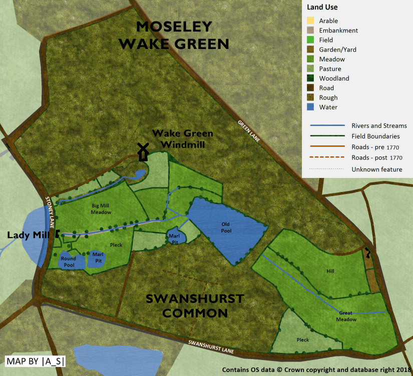
In 1770 Moseley Bog was an area of meadows, osiers and pools situated around the valley of the Coldbath Brook between the commons of Moseley Wake Green and Swanshurst Common.
Lady Mill stood to the east of Stoney Lane. It would have been a timber-framed building, infilled with red brick with a mill house alongside. Just to the south of Coldbath Brook were ill-drained meadows, osier beds and three pools formed in old marl pits.
To the north of the brook and Big Mill Meadow was a sluice (presumably fed from the mill pond) and a windmill accessed via a trackway.
Wake Green Windmill was built before 1773 and stood atop a knoll in what is now the playing fields. A sketch by David Cox here is thought to depict the windmill in 1819.
The large Old Pool was created by constructing a dam, which is still visible today.. The Coldbath Brook flowed from Old Pool through a large meadow known as Great Meadow before flowing under Wake Green Road and into Sarehole Mill Pond.
1770-1843
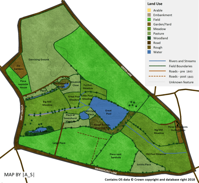
The years between 1770 and 1843 brought with them great change.
The commons of Yardley were enclosed in 1843 with the vast swathes of common land being divided and awarded to the existing major landowners, whose responsibility it was to erect boundary hedges to enclose these land parcels. It was at this time that the land north and south of the mill meadows was enclosed and brought into more formal use, including the large field north of the sluice which was called Exercise Ground in 1843 – presumably a pasture?
Lady Mill is thought to have been demolished about 1834 and the associated mill pool west of Stoney Lane gradually shrank in size.
The Wake Green Windmill had also been demolished by 1834, though there was still a comma shaped field named Windmill Close in 1843.
By 1843 the large pool was now known as Great Pool.
1843-1885
In 1850 the dam of the Great Pool had begun leaking and it was decided that the pool should be allowed to drain as the advent of steam-driven pumps meant that the holding pool was no longer needed⁵. The newly-drained area where the pool stood slowly began to be be colonised by woodland.
Other changes which had taken place between 1843 and 1885 included the construction of a large house known as The Leasowes built along the Wake Green Road. This was to be the first of a series of large Victorian and Edwardian houses to be built along this road. The landscaped gardens of the house included scattered trees and a pond.
On the 1885 map the sluice leading to the old clay pit is no longer depicted – presumably as by this point it had dried up as the Lady Mill Pool. west of Stoney Lane which fed it also gradually dried up.
There is a small sand pit marked on the map just south of Wake Green Road.
Though the pond and osiers (in the SW corner of the site) still seem to be marked on the map, the other pond just SW of the now-drained Great Pool is no longer shown.
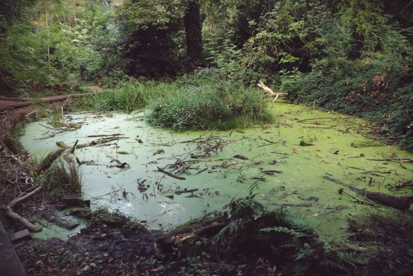
A small pit to the north east of the former Great Pool, probably originally dug for material to build the pool dam, had now flooded and is marked as a pond – this pond still exists today (photo below):
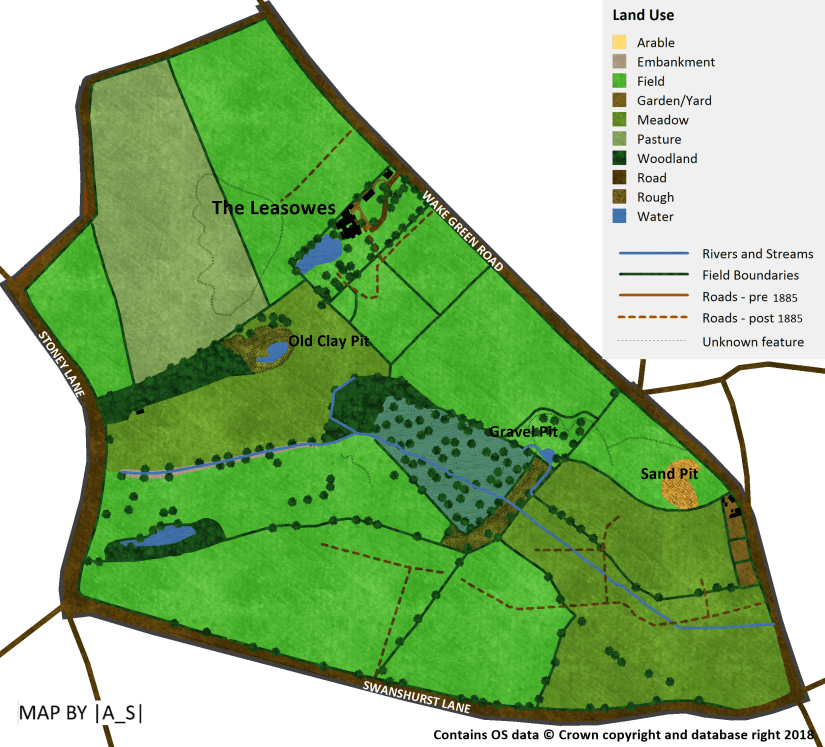
1885-1904
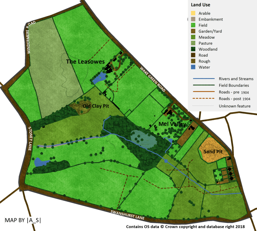
By the next map in 1904 a second large house, called Mel Valley had been constructed along with landscaped gardens which incorporated the pond in the flooded gravel pit. It has been suggested that Mel Valley was so called due to the honey bee (Apis melifera) hives in the gardens.
The old clay pit pond to the north had now dried out and was becoming colonised by woodland.
The sandpit off Wake Green Road had now doubled in size and smaller houses had begun to be built just to the south of it.
1904-1956
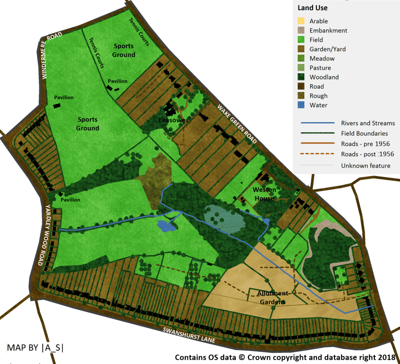
Quite a lot happened between 1904 and 1956.
The countryside around Billesley and Wake Green was becoming increasingly built on as post-war housing was constructed on a large scale. Houses now completely lined Swanshurst Lane and the corner of Windermere Road and the now renamed Yardley Wood Road, which had been raised and straightened in 1926.
Further south along Yardley Wood Road stood a row of small ‘pre-fabricated’ built as a temporary solution to the housing shortage caused by damage from air raids during the second world war.
In 1935 the woodland on the site of the former Great Pool was purchased by Birmingham City Council’s Education Department.
Mel Valley had now been renamed Weston House and other large houses had now also been constructed along Wake Green Road.
The fields to the north of Moseley Bog were now a sports ground with tennis courts and pavilion buildings.
The pond to the south west of the former Great Pool mysteriously reappeared on the map…
The meadows around the Coldbath Brook downstream from the former Great Pool were now allotments, probably converted during the second world war as part of the dig-for-victory campaign.
The large sandpit south of Wake Green Road had become disused and was becoming colonised by woodland.
1956-1968
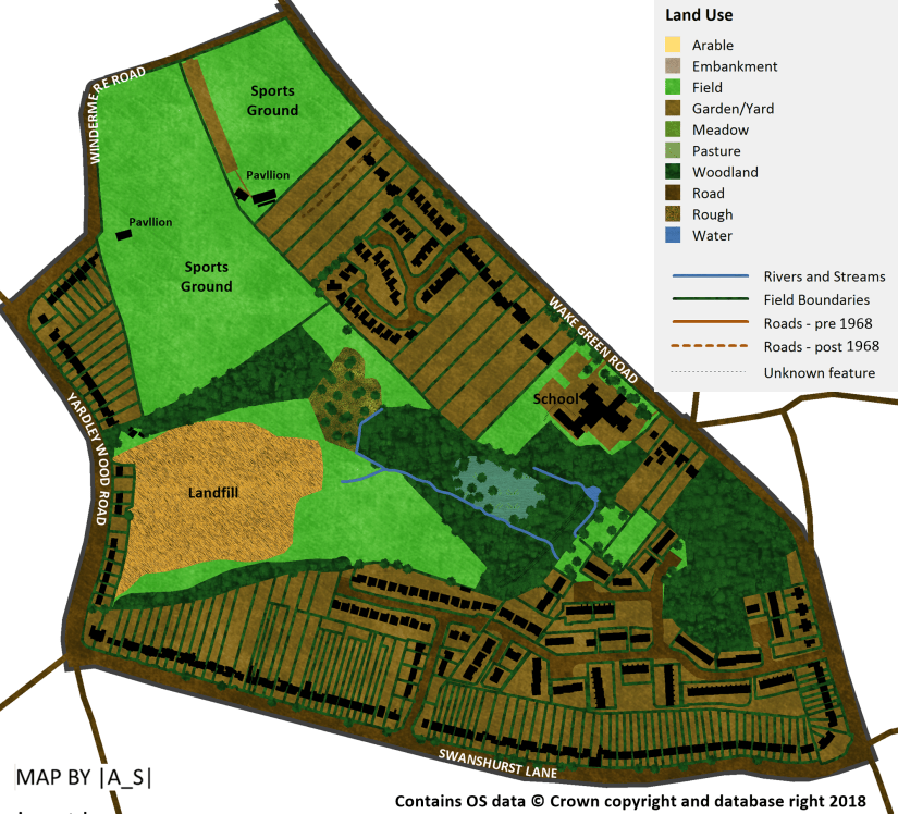
Between 1956 and 1968 development continued apace with the construction of the Swanshurst Lane Estate in 1961 including Thirlmere Drive, Comber Croft and Pensby Close. The estate was built on the former allotments and Coldbath Brook was culverted beneath the new houses.
This was followed by the construction of Meadow View in 1964.
The Leasowes was demolished aroung 1968/9 and Berkley Crescent, Mallory Rise and Adrian Croft were constructed in its place.
The other large old house, Weston House was also demolished in 1968 and was replaced by St Bernadette’s School. The pond and woodland survived.
The area west of Great Pool was used as a landfill site from 1960 to 1973 and the Coldbath Brook was culverted here.
We can be fairly certain that by this point no meadows now remained in Moseley Bog.
1968-1975

After the landfill had ceased operation in 1973 was levelled off and converted into playing fields for the nearby Moseley Grammar School. The fields were reportedly under-used as they suffered from poor drainage.
Astor Drive was built on the site of three large houses and gardens in 1975
1975-1987
In 1977 the ‘pre-fab’ houses along Yardley Wood Road were finally demolished.
During the 1980s Moseley Bog was under threat by plans to develop the site for housing but following protests by local residents the site was protected.
One of the key individuals in the efforts to save the site was Joy Fifer who led the successful “Save Our Bog” campaign in 1980 and helped kick start the Urban Wildlife movement. It was this campaign that popularised the name “Moseley Bog” for the site, which had previously been known as The Dell⁶.
The woodland and fen which had developed on the site of Great Pool was declared a Site of Special Scientific Interest (SSSI) in 1980 on account of its diverse wetland habitat.
In 1987 a major tree planting scheme took place to plant new woodland on the site.
1987 – 2005
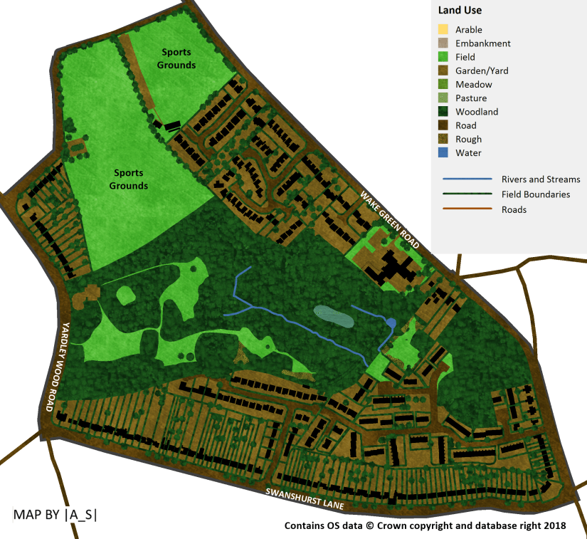
The newly-planted woodland continued to grow and mature through this period.
The whole site was declared a Local Nature Reserve (LNR) in 1991.
Moseley Bog was denotified as a SSSI in 1992 as some of the wetland interest was being gradually lost due to the fen drying out and becoming increasingly colonised by woodland.
The wildlife importance of the site was still recognised locally however through its designation as a Site of Importance for Nature Conservation (SINC).
2005-2017

In 2010 Moseley Bog became a Wildlife Trust Nature Reserve as the Wildlife Trust for Birmingham and the Black Country signed a lease to take on the management of the site.
With the support of an army of volunteers from the Friends of group and funding from sources including the Birmingham and Black Country Nature Improvement Area the Trust have managed to make significant improvements to the site including a network of new boardwalks running through the site as well as enhancement to the areas of planted woodland. New wildflower-rich meadows have also been created – marking the return of this important habitat type to the site for the first time since at least the 1950s.
")


More recently work has taken place to reverse the drying out of the important wetland areas of the site through the cutting back of encroaching scrub and trees.
You want MORE? OK well here’s a GIF I put together containing all of the maps:

¹ Acocks Green History Society (2018). Standing waters (millpools and fishponds). [www] https://aghs.jimdo.com/waters-of-yardley/standing-waters/
² John Lerwill. Billesley [www] http://www.lerwill-life.org.uk/history/billesley_c.htm
³ Acocks Green History Society (2018) The Manor of Yardley [www] https://aghs.jimdo.com/manor-of-yardley-1/manor-of-yardley-3/
⁴ John Morris Jones/AGHS. Watermills of the Cole valley [www] https://aghs.jimdo.com/watermills-of-the-cole-valley/broomhall-and-lady-mills/
⁵ Wildlife Trust for Birmingham and the Black Country (2018) Moseley Bog: Archaeology & History [www] http://www.bbcwildlife.org.uk/nature-reserves/moseley-bog-joys-wood-nature-reserve/explore/archaeology-history
⁶ Wikipedia (2018) Moseley Bog [www] https://en.wikipedia.org/wiki/Moseley_Bog
With special thanks to the Acocks Green History Society whose website is a treasure trove of interesting and useful information.

Very interesting having lived
round these arers all my life it’s nice to know we r keeping up with the history
LikeLike
Thank you, I enjoyed reading this work
LikeLike
Superb.
LikeLike
Wonderful to read and recall, lived in Swanshurst Lane 1965-1974 and spent holidays in wellies in the Bog, not always avoiding the quicksand.
LikeLiked by 1 person
Thanks, glad you enjoyed reading it!
LikeLike