
The area which is now Woodgate Valley Country Park has a long and rich history associated with it. Today, there can still be seen traces of the site’s past land use – from bronze age remains and medieval moats to ancient field boundaries and woodland as well as old trackways and signs of former industrial activity.
Introduction
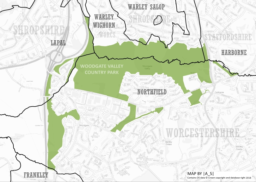
Woodgate Valley was established as a country park in 1984 combining the remaining areas of farmland that had survived the extensive urban development of the 1960s and ’70s. It lies within the modern areas of Woodgate, Bartley Green, Weoley Castle and Quinton.
Before becoming part of the city of Birmingham in 1911, the area, now covered by the Country Park was actually split between three counties, three parishes and five different townships.
The Bourn Brook marked the ancient parish boundary between Northfield, which was part of Worcestershire and the parishes of Halesowen (part of Shropshire/Worcestershire) and Harborne (part of Staffordshire) to the north and west.
Halesowen, which until 1840 was a detached part of Shropshire, was a large parish that was subdivided divided into several different townships, the following of which came to form part of Woodgate Valley Country Park:
- Lapal – which lay to the west of Lyeclose Lane/Watery Lane
- Warley – which lay east of a small brook – and was itself divided between Warley Wighorn in Worcestershire and Warley Salop in Shropshire.
Early History
Though the earliest detailed maps of the area date from the early 19th century, there are numerous other clues to the history of Woodgate Valley before this time.
It’s likely that the Bourn Brook has long since been of great local importance – both as a water source, and also as an important landmark – marking the ancient county boundary between Worcestershire, Staffordshire and Warwickshire.
Bronze Age Remains
The earliest evidence of human activity in this area comes from the Bronze Age with the presence of two burnt mounds recorded next to the Bourn Brook, one of which, near to The Wilderness Farm, has been radiocarbon-dated to about 2020 BC . In addition part of a bronze flat axe blade, thought to date from from 2000 BC-600 BC was also discovered near Stonehouse Road ¹.

Medieval Moats
The rich and productive soil of the meadows either side of the Bourn Brook would have long been important and the landscape here is known to have been farmed since at least medieval times.
Evidence of human settlement in and around Woodgate at this time includes three potentially medieval moated sites including a moat associated with the former Moat Farm ².
In addition, just south of the Bourn Brook, in Moat Meadow, it is thought that there would have been an extensive moat system, surrounding wooden farm buildings. The remains of the moat are still visible today, particularly in wet weather when it forms a pond. It’s thought that the moats in the Woodgate area probably date from the 12th and 13th centuries ³.
Roads and Trackways
It’s believed that Watery Lane, formed part of an ancient route taking salt from Wales to Lincolnshire. The hedgerow along the lane has been dated to around 1270.
There is also a historic cart track, close to the Visitor Centre, which is thought to be about 500 years old and was once the main east to west road for the area ³.
Woodland
Woodgate and the surrounding area would have relatively-well wooded in comparison to other parts of Birmingham. The 1840 map shows some quite large areas of woodland and earlier maps, such as the 1822 map of Worcestershire, and field names give additional clues to woodlands which would have been cleared just before his time.
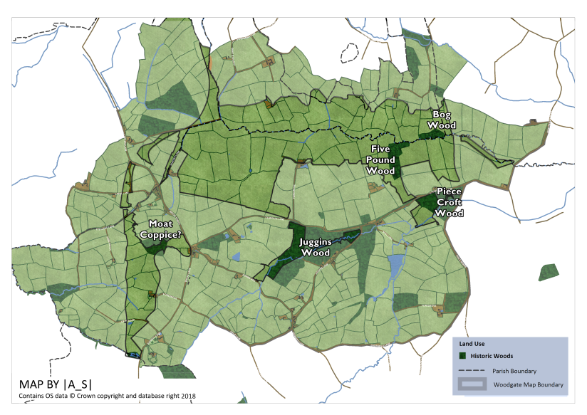
Juggins Wood
This was a large wood situated south west of the junction of Clapgate Land and Jiggins Lane along the valley of the Bartley Brook.
The former extent of the wood is shown on the Worcestershire map of 1822 but by 1840 most of the woodland had been cleared and converted to pastures and arable land while only a tiny section (the north west corner) remained.
This remaining section of woodland still exists and now forms part of Woodgate Valley Country Park.
In a report from 1989 it was described as a small but attractive remnant of an oak woodland, formerly much larger in extent. Although none of the trees are old, they are mature and the site with its old boundary bank retains the character of an ancient woodland 4.
Five Pound Wood
Five Pound Wood stood just south of the Bourn Brook, to the north east of Nonsuch Farm. It is shown on the Worcestershire map of 1822 but by 1840 it had been cleared to make way for arable land, though it’s name lived on in the name of the field. Some of the outer boundary trees of the wood may still survive as ‘assart’ woodland.
Bog Wood
Bog Wood stood just to the north of the Bourn Brook near to the boundary between Warley Wighorn and Harborne. The wood formed part of the Mopbeggar Farm Estate. The wood is shown on maps from the 1880s but it seems that the woodland had been cleared by the early 1900s, partly due to the construction of Edgbaston Golf Course. Some of the boundary trees, particularly those along the brook, may have survived.
Piece Croft Wood (Peascroft Wood)
Piece Croft Wood was a triangular wood which stood west of the junction between Stonehouse Lane and Barnes Hill. It is shown on the Worcestershire map of 1822 but by 1840 it had been cleared to make way for meadowland, though it’s name lived on in the name of the meadow. By the 1880s a large clay pit had been constructed on the land.
Moat Coppice
Moat Coppice is the name of an arable field on the 1840 map. It formed part of Moat Farm. Though it isn’t depicted as woodland on the older maps (1814, 1822) the field name suggests that it might have been woodland historically. Part of the field is now part of Woodgate Valley Country Park and a small section of boundary hedge may contain remnant trees from the former wood.
Other ancient woods, which still exist near to Woodgate Valley include Broadhidley Wood, Cooper’s Wood and Bromwich Wood.
Farming
The earliest detailed historic source that we detailing farming in the Woodgate Valley is the tithe map from 1840 which contains information on the land use, ownership and even the names of each individual field.
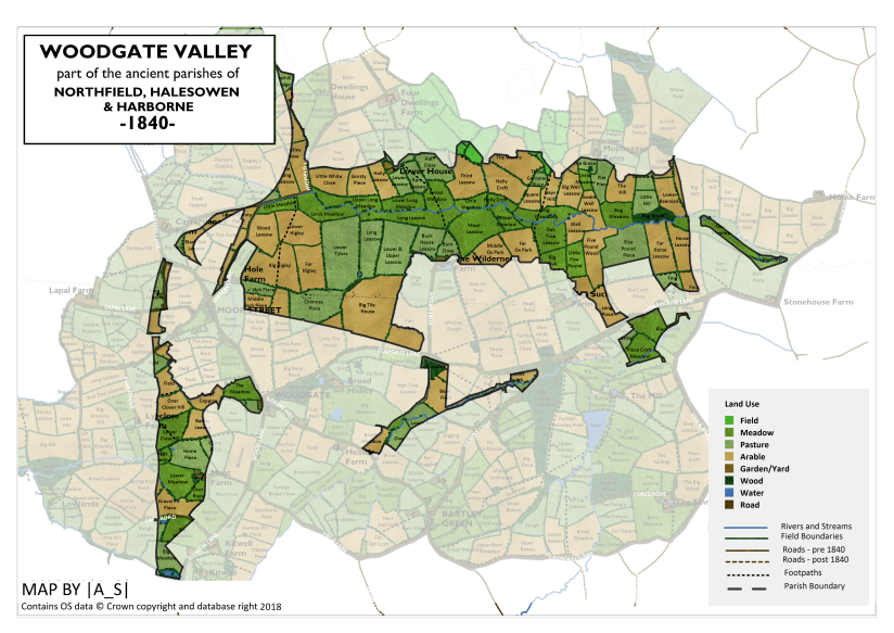
Many of these field names were quite old and can provide clues as to the historic land use or features that had disappeared by the time the 1840 map was created.
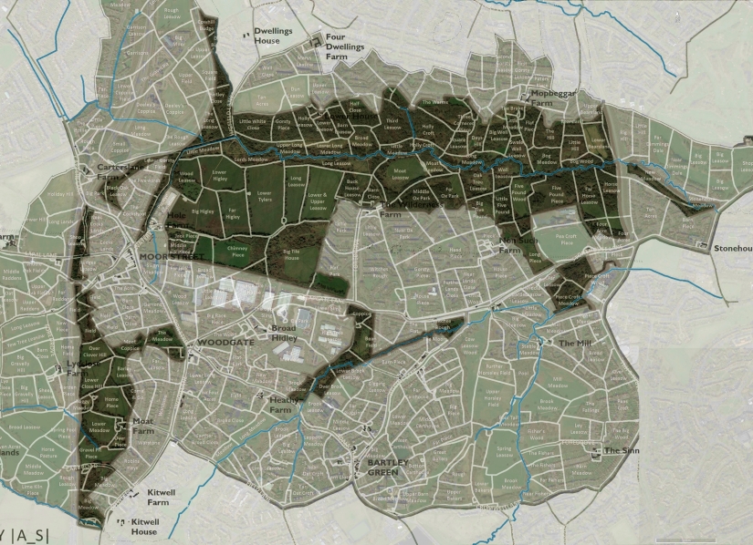
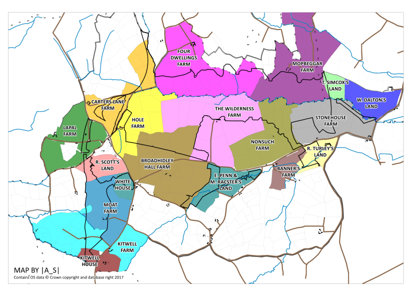
The area covered by the modern day country park was, in 1840, divided between several large farms. The land use was mainly a mixture of arable and pasture, while nearer to the brook were a series of long water meadows.
Main Valley – south of the Bourn Brook (Northfield)
Broadhidley Hall Farm
Broadhidley is first mentioned in the 13th century 5 and Hole Farm and Wilderness Farm once formed part of the Broadhidley estate, though by 1795 they were considered as separate.
Broadhidley Hall Farm lay to the north east of the hamlet of Woodgate and was bordered to the north by Hole Farm and Wilderness Farm and to the south by Adam’s Hill. An ancient cart track ran along the northern boundary of the farm.
Clapgate Lane, separated the farm in two, and it’s thought that the lane was originally created to act as a trackway to the farm.
The farmhouse stood south of Clapgate Lane just east of a block of woodland – named on the tithe map simply as “The Wood” which still exists today – later known as Broadhidley Wood, though this is outside of the modern day Country Park boundary.
In 1840 the Broadhidley Estate was owned and occupied by James Nock.
The names of two of the arable fields – Big Tile House and Little Tile House – could possibly indicate the presence of a former tile kiln site. Another field is called Chimney Piece – which may also indicate past industry – or it could be a reference to the air shaft in this field, associated with the Lapal Tunnel, which ran underneath.
Hole Farm
Hole Farm originally formed part of the Broadhidley Estate. It is first mentioned in 1344 ³, though the hedges along Watery Lane, which leads to the farm have been dated to at least 1270.
Hole Farm was bordered by Watery Lane to the west, Bourn Brook to the north, Wilderness Farm to the East, and Broadhidley Farm to the south. The farmhouse was located just off Watery Lane, and the farm buildings still exist as the Hole Farm Trekking Centre.
In 1840 the farm was owned by John Pope and occupied by Benjamin Cutler.
Some of the fields are named “Higley” – Big Higley, Far Higley and Lower Higley. This may possibly have originally have been “Hidley” – making reference to fact that the farm was historically part of the Broadhidley Estate.
The Wilderness Farm (Moor Farm)
Wilderness Farm originally formed part of the Broadhidley Estate.
The farm lay to the west of Hole Farm and was bordered to the north by the Bourn Brook. Nonsuch Farm lay to the west and to the north was Clapgate Lane.
The farmhouse stood at the end of a long foredrove (driveway) extending due north from Clapgate Lane roughly at the modern day junction with Somerfield Road. The farmhouse was situated just north of where Tibbatts Close is today. A large fishing pond was situated just to the south of the farmhouse.
In 1840 the farm was owned and occupied by Daniel Ledsam, a London Merchant who in 1809 had also bought Northfield Manor House.
Two of the fields – Moat Leasow and Moat Meadow contain features which are thought to be the remains of a medieval moat system. This may mark a previous location of the farm buildings. A small section of the moat still exists and forms a pond during wetter times of the year,
One of the fields is called Lower Tylers – possibly indicating the historic site of a tile kiln.
There is thought to have been a trial coal pit dug on the boundary between Lower Tylers and Long Leasow. A pond is shown here in the 1840 map.
Other intriguing field names include Witches Rough and three arable fields called Near, Middle and Far Ox Park – indicating that these were once cow pastures.
By the 1880’s the farm had been renamed Moor Farm.
Nonsuch Farm
Nonsuch Farm has been described as the oldest farm in this area ⁵. The farm was bordered to the west by Wilderness Farm, to the north by the Bourn Brook, to the east by Stonehouse Farm and to the south by Stonehouse Lane.
The farmhouse stood at the location of the modern day Gravel Bank and legend has it that King Charles II hid in the barn when being chased by the Royalists ⁵. A small (fishing?) pond was situated just to the east.
In 1840 the farm was owned by the Reverend William Ledsam (presumably a relation of Daniel?) and occupied by Catherine Childe.
In 1840 there is a small rectangular wood shown on the map, named Little Wood. In the northern section of the estate there was also a arable field called Five Pound Wood, which had probably been recently cleared (it was shown as woodland on an 1822 map).
To the north of this was an arable field called Well Leasow – indicating that there was probably a well here at some point.
Stonehouse Farm
Stonehouse Farm was bordered by Nonsuch Farm to the west, Bourn Brook to the north and Stonehouse Lane. The farmhouse stood at the junction of Stonehouse Lane and Northfield Road.
Stonehouse Farm is thought to be so-named because the farmhouse was constructed using stones from the ruins of the nearby Weoley Castle – at a time when most houses would have been made from timber.
In the early 1840s the farm was bought by Isaac Flavell, who was born in Gornall in 1792 and had made his fortune in America ¹. He then set up a brick and tile making business on the site (see industry section).
Main Valley – north of the Bourn Brook (Warley Wighorn)
Mopbeggar Farm (Moor End Farm)
Mopbeggar Farm was a large farm estate which straddled the border between Warley and Harborne and extended as far north as Quinton Lane. The name Mopbeggar is thought to derive from a corruption of Mockbeggar – an old and common name used to describe a large house which gave little charity.
The farmhouse was situated at the end of a meandering trackway leading south from Tennall Road, located where Simmons Drive is today.
In 1840 the farm was owned by William Penn, occupied by William Johnson.
There were a number of blocks of woodland in the estate. The northernmost of which – Pits Wood – still exists today just off Overdale Road, though it is much smaller than it was shown in 1840. The wood is outside of the Country Park boundary.
To the south, were three further woods, which fell outside of the modern day Country Park. Where Ridgemont Croft is today, was Pool Tail Plantation. This is marked on later maps (1880s) as an old sand pit. In the location of the modern day Bolney Road stood Feston Wood, which had also been cleared by the 1880s. Where First Meadow Piece is today stood Bearlands Wood (also known as Tom Knocker’s Wood).
The final wood – Bog Wood was located next to the Bourn Brook. It had seemingly been cleared by the early 1900s.
By 1904 Mopbeggar Farm had become known as Moor End Farm. (with a father and son running Moor End and Nonsuch) ⁶.
Four Dwellings Farm
Four Dwellings Farm was bounded to the south by the Bourn Brook and to the west by the Quinton Brook.
In 1840 the farm was owned by William Spurrier, a silver roller, who also owned Cotteridge House.
The main farmhouse stood at the corner of a trackway leading from Dwellings/Highfield Lane – roughly where Dimmingsdale Bank is today. The main farmhouse was occupied by Joseph Davenport.
There was also a second house – known as Lower House situated about 300 metres due south south of the main farm house – near to where Gorsley Piece is today.
It is thought that Four Dwellings Farm got its name as there were four houses standing in close proximity in an otherwise unpopulated area ¹.
Main Valley – west of Watery Lane (Lapal)
Carters Lane Farm
Carters Lane Farm was located along the western valley of the Bourn Brook directly north of a small hamlet at Moor Street. The farm extended as far north as the modern day Ridgeway. The farmhouse was located just east of Carters Lane, just south of where Junction 3 of the M5 motorway is today.
In 1840 the farm was owned by Sarah Hammersley and occupied by Richard Cooper. By 1904 it had been renamed Parkfield.
Lappall Farm (Lapal Farm)
Lapal Farm was located to the west of the hamlet of Moor Street. It was bordered by Carters Lane to the north and Lylecose Lane to the south.
In 1840 the farm was owned by Lord Lyttelton and occupied by William Wright. Lord George William Lyttleton (1817-1876) was an aristocrat and Conservative politician, whose family seat was at Hagley Hall in Worcestershire.
The farmhouse is located still stands today just off Lapal Lane South.
Pinewoods Area (Northfield)
The area of the country park south of Lyeclose Lane.
R. Scott’s Land
The northernmost farm was a piece of land owned by Robert Scott and extending from Moor Street (now Woodgate Lane) to Lye Close Lane. The farm house stood at the end of a short driveway from Moor Street and to the south was a large meadow called Garrons Meadow – Garron presumably being the surname of a former owner of the field. The farmhouse survived until the 1970s, and now Tyndall Walk stands in its place.
White House
South east of Robert Scott’s farm at a crossroads was the hamlet of Woodgate. On the western side of the crossroads stood a pub known as The White Horse. The pub is not specifically named on the 1840 map, but the building is shown and at the time and described as “Three Houses & Gardens” it was owned by Elizabeth Harvey Penn and Mary Racster, who also owned three large fields to the west of the pub.
It’s labelled on the 1884 map. By the 1950’s it seems that the pub had been converted into houses, and by the 1960s the building had been demolished.
Moat Farm
Moat Farm lay to the west of Kitwell Lane and was bounded by Kitwell Farm to the south and Lyeclose Farm to the west. The farmhouse stood at the end of a driveway opposite the junction of Kitwell Lane and Field Lane. The farmhouse was surrounded by the remnants of an old moat – indicating the farm was likely to be of medieval origin.
In 1840 the farm was owned and occupied by Isaac Whitehouse, who also owned the adjacent Heathy Farm.
Kitwell Farm
Further south along Kitwell Lane was Kitwell Farm which was bounded to the north by Field Lane and Cooper’s Brook. The farmhouse was located off Kitwell Lane, roughly where Bucknall Crescent is today and in 1840 the farm was owned by Richard Brown and occupied by James Worsey.
One of the fields was called Gravel Pit Piece, indicating the presence of gravel extraction.
Kitwell House
Kitwell House stood off Kitwell Lane south of Bucknall Close. It is thought that the house took its name from a chalybeate spring, Kitt’s Well, which was located on the west side of Kitwell Lane ¹.
Such springs had a spiritual significance from the earliest times and may have been used for baptisms.
The house accessed via a driveway from Kitwell Lane and was surrounded by pasture and an orchard. Also forming part of it’s grounds were a large pasture plus woodland and pool located west of Kitwell Lane. By 1884 it appears that the pool was dry.
The house has had a number of notable residents. Jane Loudon, nee Webb, lived at Kitwell House with her father until her marriage in 1830. She was most well known for her series of horticultural books for ladies. A blue plaque on the wall of Kitwell School in Wychbury Road commemorates her connection to the area.
By 1840 the house owned and occupied by Joshua Scholefield, a successful iron manufacturer, merchant and banker. He was elected as one of Birmingham’s two first members of parliament in 1832.
He died in 1844 at the age of 69 and was buried in Edgbaston churchyard.
Bartley Brook and Stonehouse Brook section (Northfield)
Bartley Brook flows from its source, east of Kitwell House, eastwards and joins Stonehouse Brook just north of Sennelleys Park. Stonehouse Brook then continues eastwards before joining the Bourn Brook near Elford Road. There are two sections of the Country Park along these two brooks.
E Penn & M. Racster’s Land
Elizabeth Harvey Penn, & Mary Racster owned an area of farmland either site of Bartley Brook. This land had been part of a woodland known as Juggins Wood until at least 1822. By 1840 the woodland had been mostly cleared leaving just a tiny section remaining.
The farm house was located along Jiggins Lane roughly where the junction with Green Drive is today. By the 1960s the farm house had been demolished.
Banners Farm
Crossing Jiggins Lane and moving down the valley, the next piece of land belonged to Thomas Salmon. This was a woodland known as Cow Leasow Wood and it was cleared just before 1840.
After this was Banner’s Farm which extended eastwards along Stonehouse Lane. Banners Farm was owned and occupied by Thomas Priest Wooton and the farmhouse stood east of the junction of Stonehouse Lane and Mill Lane. By the 1880s the farm house had been converted into the Royal Oak Public House before later being demolished with the rerouting of Mill Lane in the 1950s/60s ⁵.
R. Turley’s Land
Further east along Stonehouse Lane was farmland owned by Richard Turley. Before 1840 much of this land formed part of Peascroft Wood which was located between Stonehouse Lane and Barnes Hill.
Industry
There are numerous traces of industry before 1840, with evidence of tile kilns and gravel pits at various locations within the country park, as well as, of course, the Lapal tunnel, built in 1792. Though the 1840 map doesn’t yet show much other evidence or industrial activity, that was all soon to change.
Canals
Though farming still dominated the landscape up to 1840, already there had been the first signs of the industry which was to later transform parts of the area. In 1798 the 3.4 km long Lapal Tunnel, which helped to connect the Dudley No. 2 canal in Lapal to the Birmingham and Worcester Canal at Selly Oak was opened.
Although the tunnel went underneath Woodgate Valley, there were still some traces on the surface including spoil heaps along the route of the canal, and an air hole – some of the spoil heaps are still visible.
Constructing such a long tunnel was clearly an (over?)ambitious project, and over the years the tunnel suffered from a number of collapses before being eventually abandoned in 1917.
Brick and Tile Works
After purchasing Stonehouse Farm in 1842 Isaac Flavell soon set up a brick and tile making business on the land and initially lived in the farm house, moving to the California Inn by 1851. He also owned a canal wharf in Gas Street. He died in 1870 but brickmaking at this site continued – following Isaac’s death the enterprise was acquired by James Smart who set about expanding the business ⁶.
The 1880s map show that by this time the area around Stonehouse Lane was now known as California – a name inspired by Isaac Flavell’s previous business ventures there.
At this time there were three brick and tile works located off Stonehouse Lane/Barnes Hill ⁷.
Top Yard, which included a large claypit and several kilns stood north of Stonehouse Lane on the site of the present day Hillcrest School. A second larger claypit located where the Fire Station now stands. This was linked via tramway to a large brickworks building located north of the canal east of Barnes Hill.
Middle Yard, which included a claypit connected by tramway, was located west of Jiggins Lane, just south of the Stonehouse Brook on the land previously owned by Richard Turley.
The third brick and tile works was Bottom Yard – located east of Barnes Hill.
By 1851 to the north of Top Yard stood two small cottages known as Five Pound Cottages. The manager of the Brickworks lived in one of these and this cottage was named Eagle Cottage (no doubt because it offered a bird’s eye view over the area) ⁶.
To the north of the cottages was a pumping engine and an old coal shaft, which is said to have been sunk by Isaac Flavell in the 1840s to provide coal for the Brick and Tile Works. It appears that the shaft had to be abandoned due to influx of water ².
By 1905 the cottage was known as Coalpit House. The two cottages may have been combined by this point.
Top Yard had ceased trading by 1911 6 . In the 1960s the Bartley Green Grammar School for Girls was built on the site and Coalpit House was demolished.
The farmhouse survived until the 1930s, when it was demolished and replaced by the Stonehouse Pub.
20th Century Industry
Birmetals
In 1936 Birmetals was built on part of the farmland of Broadhidley Farm – which would have dramatically altered the previous rural character of the area. In association with with development, Clapgate Lane was re-routed and widened. Birmetals was a rolling mill for high tensile aluminium alloys to supply to aircraft, marine and other industries. The company closed in 1980.
The site became Woodgate Business Park.
Landfill Sites
A series of landfill sites have been in operation within the modern day country park ⁹. Many of these made use of the claypits which had been dug in association with the former brick and tile industry.
Birmetals Tip
The first of these – to the east of the playing fields was Clapgate Lane Landfill Site, owned by Birmetals and accessed via a trackway from Clapgate Lane. The landfill site was active from 1938 until its closure in 1977. The area is now woodland.
Hillcrest School Landfill Site
This landfill was the former claypit associated with the brick and tile works. This was capped before the 1960s and is now the school playing fields.
West Boulevard Landfill Site
Directly to the east of the landfill site below, was the West Boulevard Landfill Site, in the second (and larger) of the two claypits. The landfill site was accessed via a trackway off Stonehouse Lane, just north of the junction with Barnes Hill. It was operational between 1966 and 1974 and now forms part of the country park.
Land South of Stonehouse Lane
The final landfill site was located south of Stonehouse Lane, just north of the Stonehouse Brook. This was another former claypit and it’s thought that this was a landfill site as early as 1904, though by the 1970s it was no longer in use.
20th Century Urban Expansion
Golf Courses
Edgbaston Golf Course
In 1910 much of the farmland of Mockbeggar Farm was converted to a golf course for Edgbaston Golf Club which had moved from its original home at Warley Woods where the club had been based since 1896 ⁸.
The laying-out of the new golf course meant quite a few of the farm hedges were removed.
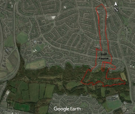
The Club House was located just south of Ridgeacre Road, in the location of the modern day Quinbourne Community Centre.
The golf course existed here until 1935, at which point the club relocated to its current home at Edgbaston Park.
Roads
M5 Motorway
In 1962 the M5 motorway and Quinton Expressway were constructed through the western part of the area, slicing through Kitwell Farm, Lye Close Farm, Lapal Farm and Carters Lane Farm. The farmhouse of the latter was demolished and this is now the location of junction 3 of the motorway. The farmland to the west of the motorway remained as farmland, while that to the east was either developed, or became part of Woodgate Valley Country Park.
West Boulevard
More recently, in the 1980s, West Boulevard was extended from its existing terminus at the junction with Quinton Road West all the way southwards to meet with Stonehouse Lane/California Way. This cut through Woodgate Valley and separated the section at Wentworth Way from the rest of the main valley.
Housing
During the 20th century, the continued expansion of Birmingham meant that more housing was needed. Large scale housing development of the area began in the 1930s and occurred in stages until the mid 1980s.
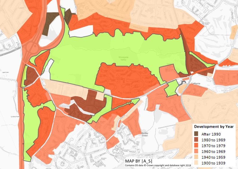
In 1935 the Birmingham Corporation compulsorily purchased the land on which the golf course was laid out. By 1938 work had begun on constructing housing on the northern part of the course down to the newly-constructed Quinton Road West.
Development was creeping ever closer towards the Bourn Brook, and the 1970’s saw the southern section of the farmland at Nonsuch Farm and Wilderness Farm developed to build the Woodgate Valley South estate, with Somerfield Road looping through it. The farm houses were demolished.
There was a similar story in the north as new roads including Highfield Lane and Simmons Drive were constructed.
In the far south of the area, the farmland east of Wood Lane had already been built on by the 1960’s and the farmhouses of Kitwell Farm and Heathy Farm had been demolished. By the 1970s development also expanded west of Wood Lane and the eastern section of the farmland of Moat Farm made way for Pinewoods Drive. The farmhouse appears to have survived at least until the early 1980s, but it has since been demolished.
By the 1970s Kitwell House had also been demolished and Kitwell Substation now stands there.
In the late 1970s/early 80s part of Broadhidley Farm was developed for housing (Bartley Woods) and the farm buildings were demolished.
Country Park Status
In 1980 much of the Valley was zoned as Open Space, apart from 38 ha at the western end, which was to be developed for industry, including the construction of a new link road 7. Local opposition to the plan managed to win the backing of the City Council and instead it was agreed that the entire site was to be designated as a Country Park in 1984 and be managed for the purpose of nature conservation.
Woodgate Valley Today
The valley remains an encapsulated piece of countryside in the urban area, offering us a glimpse of the landscape history of this far northern part of old Worcestershire.
Despite the surrounding development, the farmscape of the country park has remained remarkably intact, with up to 70% of the hedgerows from 1840, still at least partly present. In 1840 there were about 25 kilometres of hedgerow. Between 1840 and 1880 there were a few minor alterations to field boundaries,with some hedges removed and others planted in new positions. By the 1930’s there had been some changes, with the laying out of a golf course on the north eastern part of the site – leading to the loss of quite a few hedges.
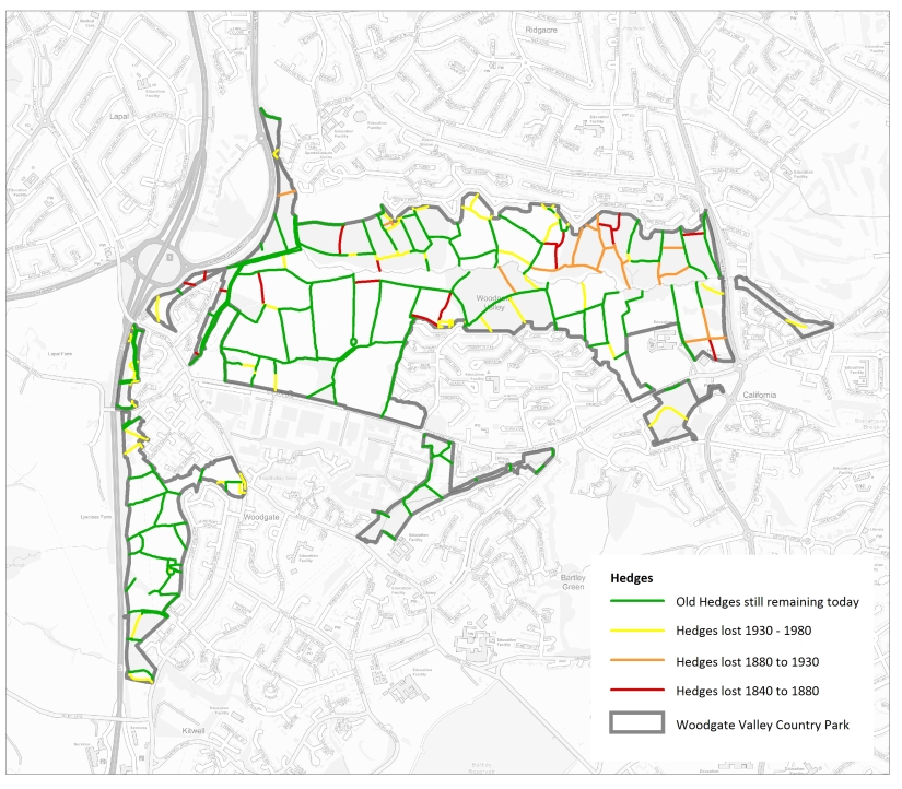
From the 1960s onwards farming declined in the area and it’s likely that after this time many of the hedges would have seen their condition deteriorate due to lack of management, with gaps appearing in some hedges, and other hedges starting to expand outwards to form scrub or woodland.
| Year | Total length of old (pre 1840) hedges) km | Percentage loss since 1840 |
| 1840 | 25.13 | – |
| 1880 | 23.54 | 6.4% |
| 1938 | 21.44 | 14.7% |
| 1984 | 17.76 | 29.4% |
Following the designation of the site as a country park, a series of landscape proposals were produced, with a strong focus on tree and shrub planting. A series of several blocks of woodland were planted, particularly in the area north of the Bourn Brook. Now, 30-odd years later the original blocks of woodland have grown quite substantially and engulfed some of the former hedges.
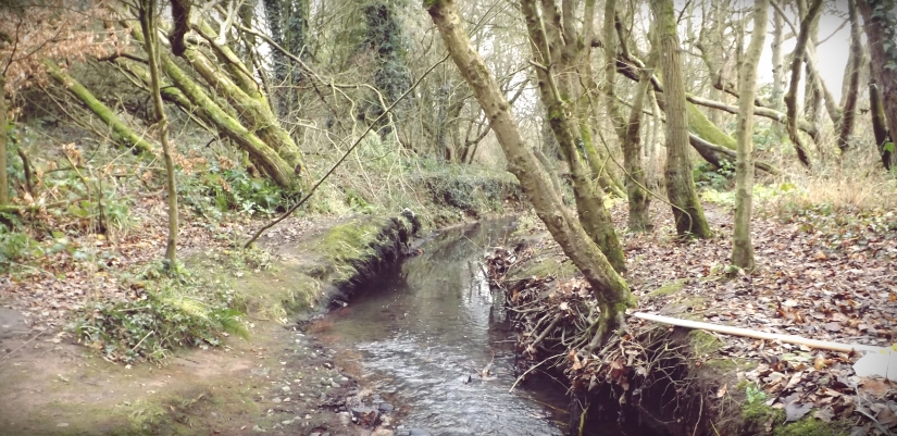
At the centre of the park, the Bourn Brook forms a focal point. Though the brook, appears rather naturalistic in parts, during the 1960s and 70’s a number of ‘improvements’ were made in an attempt to deal with the large flows of run-off from the urban catchment 7. This included straightening some of the stream’s meanders, replacing parts of the natural banks with gabions and the building of several weir structures.
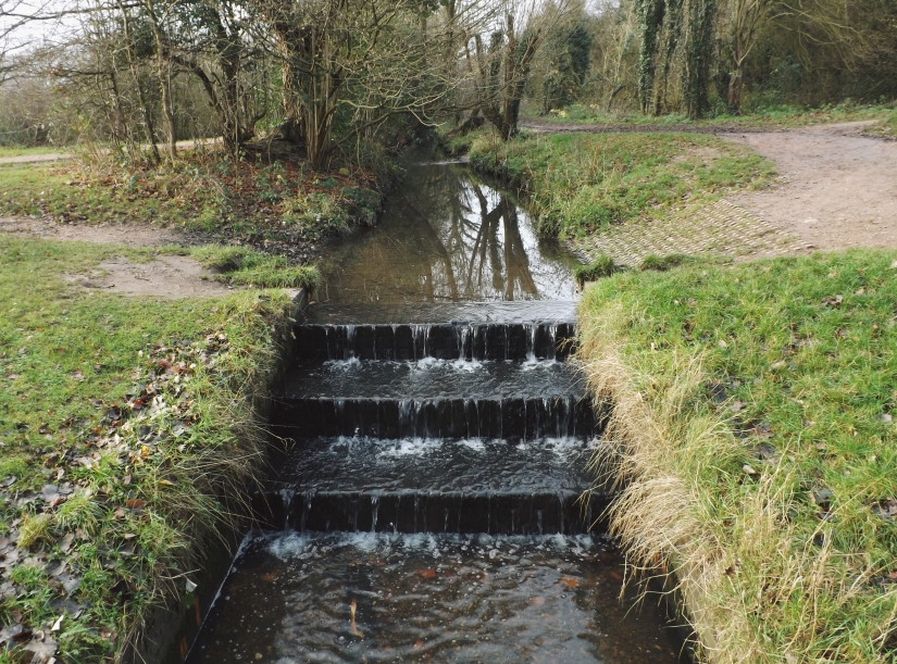
Recently (from 2016 onwards) there have been moves to restore the brook to a more natural state including removing the weir structures where possible, in order to allow fish to more-freely migrate upstream and also to let the stream system better respond to water pollution/water quality issues.
Woodgate Valley is a very important place for both wildlife and people. The country park rangers carry out a range of habitat management, often helped by volunteers and also lead other activities.
References
- Dargue, W (2018). A History of BIRMINGHAM Places & Placenames from A to Y. [www] https://billdargue.jimdo.com/
- Halstead, J (1989). Woodgate Valley: A Preliminary Field Survey and Desktop Assessment
- Birmingham City Council (2018). History of Woodgate Valley. [www] https://www.birmingham.gov.uk/info/20089/parks/404/woodgate_valley_country_park/4
- Woodgate Valley SINC Citation (1989). EcoRecord
- Bartley Green District History Group – http://bgdhg.co.uk/index.htm
- Surman, M (2018) pers. Coms.
- Parry, C (1999) Woodgate Valley Country Park Management Plan. The Wildlife Trust for Birmingham and the Black Country.
- Edgbaston Golf Club (2018). History of the Club. [www] https://www.edgbastongc.co.uk/history
- Environment Agency (2018) Historic Landfill Sites. [www] https://data.gov.uk/dataset/17edf94f-6de3-4034-b66b-004ebd0dd010/historic-landfill-sites
Maps
- Birmingham, Sutton, Stourbridge – OS Drawings (1814-17)
- Worcestershire – Pringle & Greenwood (1822)
- Northfield – Tithe Map (1840)
- Lappal – Tithe Map (1840)
- Harborne – Tithe Map (1842)
- Ridgeacre – Tithe Map (1844)
- Warley Wighorn – Tithe Map (1845)
- Worcestershire OS County Series (1885)
- Staffordshire OS County Series (1885)
- Warwickshire OS County Series (1885)

The foundations of Kitwell House could still be seen in 1954 along with walnut tree’s.
The pools were full of water, we collected frogs, crested and common newts.
Also the remains of cottages and gardens on the other side of Kitwell Lane.
I was ten years old.
LikeLike
Very impressed with your history of Woodgate Valley. I am interested in writing a relatively brief 20th century social/planning /environmental/political history of Woodgate Valley and Woodgate Valley Counrty Park up to the present day for The Bartley Green History Group and Quinton Local History Society.
LikeLike
Is there a local Museum with details of the Bronze Age burnt mounds etc. ?
LikeLike