
Before becoming part of the city of Birmingham in 1911 Moseley used to be part of Kings Norton Parish in the county of Worcestershire. Kings Norton Parish was divided into ancient divisions for tax reasons known as ‘yields’ and Moseley was within the Moseley Yield along with Kings Heath, Balsall Heath and Brandwood End.
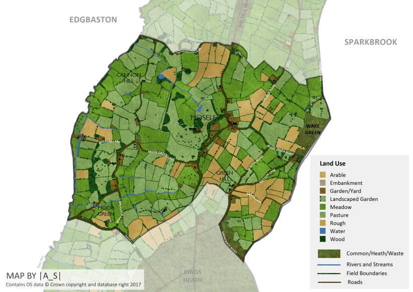
The boundaries which I’ve used for the map of Moseley are as follows:
Starting from the northernmost tip of Moseley, moving clockwise from the River Rea, the boundary follows Edgbaston Lane (now Edgbaston Road), crosses the Alcester Turnpike (Alcester Road) roughly where it meets the modern day Trafalgar Road, and then zig-zags along field boundaries before joining Yardley Wood Road. From here the boundary follows that of the ancient parish boundary between Kings Norton and Yardley: following Belle Walk and Bully Lane (Billesley Lane). Here the boundary departs from the parish boundary and follows Springfield Road and then Lett Lane (School Road) northwards. Opposite Green Hill House the boundary turns eastward towards the railway before following the railway southwards, before following Dads Lane and then the River Rea northwards all the way back to Edgbaston Lane.
Wake Green, the area east of Belle Walk and Billesley Lane isn’t included in this map as at this time it fell within the separate parish of Yardley.
Moseley before 1838
The settlement of Moseley has ancient origins, possibly in the form of the Saxon settlement of ‘Mus leh’ whose name is thought to mean ‘fieldmouse clearing’. The settlement is then listed as ‘Museleie’ in the Domesday Book of 1086 as one of a number of berewicks of Bromsgrove.
Moseley was referred to as a manor from at least 1456 and had its own manorial lord and manor house, which has stood on a number of sites in the village over the years.¹
In the 16th century the manor came into the possession of the Grevis family who built up land holdings in the area over time, including Sir Richard Grevis (d. 1632) who was a favourite of James I, High Sheriff of Worcestershire and Lord of the Manors of Yardley and Solihull. The Grevis family went through a period of financial decline and as a result the estate was sold in 1764 to John Taylor of Bordesley Park, a wealthy button manufacturer, who bought the Moseley Hall estate for his son John Taylor II.
Moseley is thought to have had a small village centre from the Middle Ages and most of the population was involved in agriculture with the Moseley Hall estate being a major employer.
A couple of events took place before 1838 which were to eventually transform Moseley from a small rural settlement to an affluent suburb of an ever-expanding Birmingham.
In 1767 the main road through Moseley was put in the care of a turnpike trust in order to maintain and improve it² and shortly after this in 1772 the Enclosure Act was passed which resulted in the enclosure of the large tracts of common land which lay to the north and south of Moseley – Balsall Heath and Kings Heath respectively.
The junction of Wake Green Road and Alcester Road probably wasn’t always the centre of the village however as it is thought this this would have originally been at the junction of Lady Pool Lane (now Church Road) and Wake Green Road. At this location once stood the original village green with an Elizabethan timbered farmstead known as Village Green House. The new village green was created in around 1801.
The map below shows Moseley how it may have appeared in around 1770.
Moseley in 1838
By 1838 the heaths to the north and south of Moseley had been enclosed and new development was taking place in both Balsall Heath and Kings Heath. Another significant change which took place around this time was the construction of the Birmingham and Gloucester Railway, which was completed in 1840 with the opening of Moseley Station, which was later renamed Kings Heath station with the construction of the new Moseley Station off Woodbridge Road in 1867. Moseley Tunnel which was built in order to to protect St Mary’s Church from vibration and noise was the first part of a railway to be built in Birmingham. The sand and gravel excavated here was used to build up the Balsall Heath embankment.
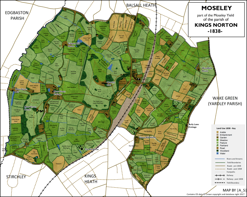
Moseley in 1838 was still predominantly a rural landscape comprised of scattered farm estates with a mixture of meadows, pastures and arable land. The area of Moseley to the west of the Alcester Turnpike Road drained towards the River Rea via a number of small streams including (going south to north) Shuttock Stream, Moorgreen Brook and Moseley Brook.
By 1838 the following roads were already in existence:
| Present Day Name | Tithe Map Name (1838) | Other Names |
| Alcester Road | Alcester Turnpike Road | Digbeth to Spernal Ash Turnpike |
| Belle Walk | Road | |
| Billesley Lane | Bully Lane | |
| Church Road | (part of) Lady Pool Lane | |
| Cotton Lane | Road | |
| Dads Lane | Dads Lane | |
| Edgbaston Road | Edgbaston Lane | |
| Greenhill Road | Green Lane | Love Lane (mid-19th Century) |
| Holders Lane | Road | |
| Moor Green Lane | Moor Green Lane | |
| School Road | Road | Lett Lane (c1770) |
| Shutlock Lane | Road | |
| Springfield Road | Road | |
| St Marys Row | Road | |
| Wake Green Road | Road | |
| Yardley Wood Road | (part of) Stoney Lane |
In 1838 the following roads existed but in the present day are no longer in existence:
- Carriage Drive – leading to The Henburys – now the pathway leading through Highbury Park
- Carriage Road – leading to Cannon Hill House – now the pathway leading through Cannon Hill Park
Moseley Village
Moseley Village itself was (as it still is) centred around a village green at the junction of Alcester Road and Wake Green Road (Salisbury Road was not yet in existence).
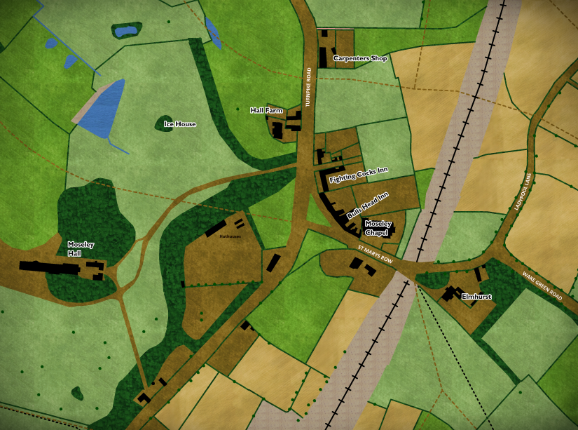
Moseley Chapel (St Mary’s Church)
The chapel is first mentioned in 1405 and it was thought to have been built as a response to a petition by local people who were fed up with having to make the long, often treacherous journey to St Nicholas’ Church in Kings Norton. The church and it’s grounds have undergone several modifications over the years with the construction of the railway severing the church’s lands in two – with Chapel Field to the east of the church being cut in half by the cutting for the railway before being partially filled back in to construct the tunnel to protect the church from noise.
Bulls Head
Facing the village green was the Bulls Head Inn, along with its stables and garden plus 13 houses which were all owned by Joseph Webb, who also owned a parcel of land to the rear which would eventually become part of the churchyard of Moseley Chapel. Of the various tenants occupying the buildings only John Millward is mentioned by name (the innkeeper?).
The Bulls Head is the oldest pub site in Moseley, with a pub standing here since at least 1700.
Fighting Cocks
Next along, after the row of houses stood the Fightings Cocks Inn plus stabling and two tenements and garden. The present day Fighting Cocks building was built in 1899, and was situated just north of the original site. It replaced an earlier Fighting Cocks (the one shown on the map) built in 1778, which itself was built to replace an earlier pub called the Fox and Dogs, which is thought to have occupied this spot since 1750³. In 1838 it was owned and occupied by Mary Todd.
Moving northwards next up was a carriageway (the future Edwards Road) followed by three houses and gardens owned by Mary Cooper and Diane Todd. Next to these was a pasture known as Upper Bare Piece. North of this field and just south of the current day Prince of Wales (not yet built) stood a house, carpenters shop, pleck and garden belonging to George Johns.
South of the Village Green
South of Wake Green Road stood a large house and garden owned by Robert Blayney and occupied by William Phillips. By 1884 this house had been demolished and replaced by higher density housing as development of Moseley as a suburb was by then well underway.
West of the newly constructed railway, just south of the junction with Lady Pool Lane (now Church Road) stood another large house and landscaped garden, known as Elmhurst. The house was owned by John Gibson Reeves and this site is thought to be the location of the original village green before it moved westwards. It is thought that this house replaced an earlier Elizabethan timber-framed farmstead, called Village Green House ⁴.
Moseley Hall
Dominating the western side of the Alcester Turnpike Road (and village life in general!) was the Moseley Hall estate.
The original medieval hall is thought to have stood on the site of King Edwards Road and this was replaced by a hall, built in 1632 in neoclassical style, on the opposite side of the Alcester Road on the site of the current day hall. This incarnation of the hall was severely damaged during the Birmingham Riots in 1791 – leading to the hall being rebuilt in 1796, in roughly its modern day form, with it’s grounds redesigned in a parkland style.
In 1838 the hall was owned and occupied by James Taylor, who was soon to become Tory MP for East Worcestershire in 1841. In 1838 along with the hall itself the estate consisted of ‘out offices’, parkland including an orangery, shrubberies, blocks of planted woodland, ice house and a lake.
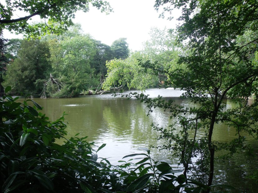
The hall continued as the seat of the Taylor family until it was bought by Richard Cadbury in 1884. When Salisbury Road was constructed it cut the parklands of Moseley Hall in two – with the house on one side of the road and the lake on the other. To prevent the development of the northern part of the grounds nine local businessmen and residents formed the Moseley Park and Pool Estate Company, leased 14 acres of the land and laid out a new park. The southern part of the parkland is today the grounds of Moseley Hall Hospital with the hall forming part of the hospital itself.
Hall Farm
In addition to the hall and it’s parkland there was a house and farm buildings located along the western side of Alcester Turnpike Road, a kitchen garden, shrubberies and a hothouse. Facing the village green were three additional houses. North of the northernmost approach drive to the hall was Hall Farm, also owned by James Taylor and occupied by Richard Anterton. The farm consisted of a house, stable, garden, farm buildings and yards and stood just behind where Dixons Estate Agents stands today. The farm’s land extended northwards just past the present day junction with Park Hill.
Moor Green
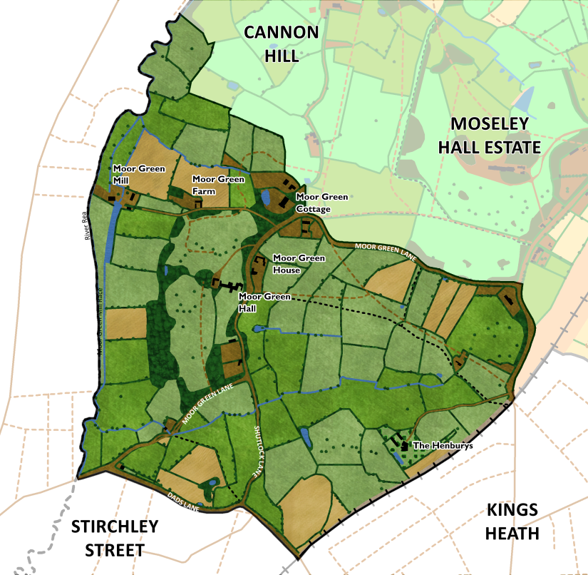
Moor Green may be a name of Anglo-Saxon or medieval origin and is thought to mean ‘common pasture by the marsh’. The green itself was at the junction of Moor Green Lane and Shutlock Lane.
Moor Green Hall
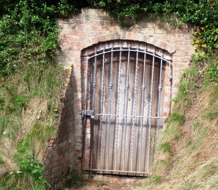
Aside from the Moseley Hall Estate iself, James Taylor also owned other large tracts of land both in Moseley and beyond including the Moor Green Hall Estate. Moor Green Hall stood west of Moor Green Lane and was surrounded by landscaped gardens including scattered trees and blocks of woodland. One of these blocks of woodland still survives today as Holders Wood, which may be of ancient origin (though replanted), as indicated by the presence of boundary earthworks and slow-colonizing ancient woodland indicator species such as Pignut⁵. There was thought to be an ice house situated in the wood in the past.

The hall in 1838 was occupied by Sarah Taylor. The hall was later the home of was the
home of Arthur Chamberlain (brother of Joseph Chamberlain). The hall was used as a military hospital during the first world war and was demolished in the 1920s.
Moor Green Farm
Down the trackway leading from what is now Holders Lane, there was Moor Green Farm, which was at that time occupied by John Knowles. There are records of a Moor Green Farm that date back to 1743. The farm extended southwards almost all the way to Dogpool Lane. This land is now Holders Lane Playing fields
Moor Green Mill
Moor Green Mill stood at the bottom of the track by the River Rea and possessed a long narrow mill pool. In 1838 the mil is described as a ‘grinding, rolling and blade mill’. A mill is first recorded at this location in 1597. In 1838 it was occupied by Charles Umpage.
Moor Green House
Moor Green House stood east of Moor Green Lane and was owned by another notable landowner of this time, William Congreve Russell, a Whig MP elected in 1832 as one of the two Members of Parliament for East Worcestershire until he stood down in 1835. From 1839 he held the post of High Sheriff of Worcestershire.
Later, by 1898 the Moor Green Estate had passed into the hands of John Charles Holder, a wealthy brewer, after whom it is assumed that Holder’s Lane is named.
Moor Green House was demolished in 1920 and was replaced by an office block which has recently been converted into high-end apartments.
Moor Green Cottage
Moor Green Cottage stood north of the junction of Moor Green Lane and Holders Lane. In 1838 the cottage was owned and occupied by John Arnold and was set in a landscaped garden with woodland and a pool. The house was later bought by John Charles Holder, who demolished it and built Pitmaston House in its place in around 1870. The pool still survives today.
The Grange (Hamper Estate)
Between Moor Green Lane and Dads Land and extending westwards over the boundary into Kings Heath was The Grange Estate centered around a large 18th century mansion along with associated offices, farm buildings and gardens. The Grange estate included the northwestern corner of the present day Highbury Park. The estate was cut in half by the construction of the Birmingham and Gloucester railway.
In 1825 the house was inhabited by William Hamper Justice of the Peace for Warwick and Worcester. After William’s death in 1831 the estate passed to his daughters, Eliza Hamper, Sarah Sharpe, Mary Jane Hamper and Lydie Anne Hamper who are listed as the landowners by the time of the 1838 map. The house and land was occupied by Thomas Sharpe who is thought to have been Sarah’s husband.
The Henburys
Henbury, thought to be derived from an Anglo-Saxon word – heyne burh meaning ‘high burgh’ was shown on maps from 1798 onwards. The Henburys was located in the southern area of the present day Highbury Park and was surrounded by a small farm. In 1838 it was owned and occupied by Charles Ratheram.
The original farmhouse and its buildings were cut off from the estate when the Birmingham to Gloucester railway transected the estate in 1837 and these were replaced by new buildings near the house⁶.
The house was demolished in 1965 through a garden wall and a pond still remain.

Cannon Hill
Cannon Hill is believed to take its name from the day that Royalist troops camped here on their way to the Battle of Naseby in June 1645⁷.
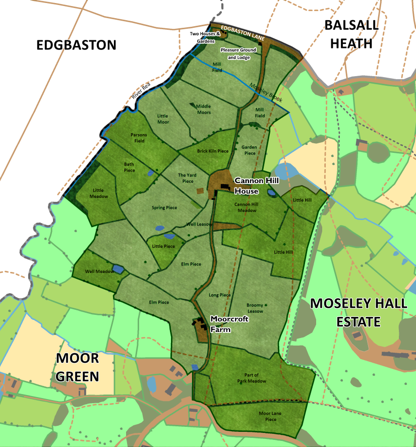
Cannon Hill House
A lodge stood on Edgbaston Lane and alongside was a winding carriageway which led all the way from Edgbaston Lane to Moor Green Lane. Along the trach stood first Cannon Hill House and further along Moorcroft Farm. When Russell Road was built (sometime before 1884), the southern section of the trackway became disused and the southern section formed part of the path network of Cannon Hill Park.
Cannon Hill House was believed to have been built in the 1830s and in 1838 it was owned by Samuel Ryland, who died in 1843 leaving the estate to his daughter Louisa Ann Ryland (1814–1889) who, in 1873 gave the land, known as Cannon Hill Fields, to Birmingham City Council and paid for the draining of the site to create a public park⁸.
Moorcroft Farm
In 1838 Moorcroft Farm was owned by William Congreve Russell and occupied by John Austin and the farm’s land extended northwards from Moor Green Lane to just south of Cannon Hill House. Moorcroft Farm was demolished sometime in the 1960’s to be replaced by Torridon Croft.
Green Hill
Green Hill existed as a hamlet based around the southern end of Lett Lane (School Road) and now straddles the modern day border between Moseley and Kings Heath.

Greenhill House
North of Poplar Road was Greenhill House owned by John Chatfield Mott, a currier who lived there in 1838 with his wife and his wife’s unmarried twin sister. The estate stretched northwards up to the railway. By 1904 the house had been demolished and Valentine Road had been built here.
Greenhill Cottage
Further north along School Road (roughly at the current day location of Birches Close) stood a cottage also owned by John Mott, called Greenhill Cottage. In 1838 it is listed as being tenanted by Harry Thrupp. A school was opened here in 1824 by Charlotte and Anna Maria Thrupp with 15 pupils. The sisters ran the school together until November 1839 when Anna died and was buried in Moseley Churchyard. Charlotte continued to run the school on her own until 1847. Greenhill Cottage is shown on maps all the way up until the 1970s.
In about 1868 the school moved to a new location which is now occupied by Moseley C of E. It closed c.1915 and after a brief spell as a YWCA hostel for young women it was taken over by Woodrough School in 1921.⁹
Green Hill House
Green Hill House stood at the Junction of Lett Lane (School Road) and Green Lane (Greenhill Road). The The house was owned by Robert Blayney of Evesham (1818-1856) whose father (also called Robert) was Lord of the Manor of Garford and possessor of estates at Dripshill, Moseley, Kings Norton and Northfield. Robert Blayney (the younger) succeeded his father in 1838. Robert was a Captain in the Worcestershire Militia, and a Deputy-Lieut. for the county of Worcester.
The farm was occupied by Thomas Docker and the farm’s land extended eastward almost to Bully Lane (Billesley Lane). By 1884 Green Lane had been straightened and Greenhill House had been demolished.
The ‘New’ Green Hill House
On the opposite side of Lett Lane (School Road) stood a farm belonging to the trustees of the late William Shorthouse (named as Joseph Thomas Southall Shorthouse and William Nutter). In 1838 the farm was occupied by Rebecca Shorthouse. The farmhouse had a carriage leading to it and was set in landscaped gardens with lawns, woodland and a pond.
Confusingly after the demolition of Greenhill House on the opposite side of the road, THIS house is then subsequently depicted on maps as Greenhill House… Byb the 1930’s this Greenhill House too had been demolished to make way for Greenend Road.
Further up the lane on the same side was arable land and pasture belonging to Reverend William Morrall. On the map from 1884 a vicarage is shown on this land.
National School

Towards the top end of School Road stood a building, owned by James Taylor and occupied by Richard Jones which in 1838 was listed as a ‘National School’. The school was founded in 1828 as The Moseley Church of England National School.
A school building is still shown in this location on maps up until 1969, when a new school was built on the corner of Oxford Road. The original school site is now the location of a retirement home.
The land between Lett Lane and Cotton Lane was owned by Paul Moon James and occupied by Francis Tomes. A house, offices, lawn and garden was situated along a crescent-shaped driveway off Wake Green Road. By 1884 a house, called The Dingle is shown here.
The land between Cotton Lane and Bully Lane (Billesley Lane) was owned by The Poor of Kings Norton. There were two houses on the land – the first, which stood on the corner of Cotton Lane and Wake Green Road was occupied by George Cotton and a second house, located along a driveway off Wake Green Road was occupied by John Joseph Bramah. In 1884 this house was called The Laurels.
Bully Lane Cottage
Located off Bully Lane (Billesley Lane) was a farm owned by Ann Peake and occupied by John Handley. The farm building appears to have been demolished by 1905 and was located roughly where the entrance is now to Moseley Tennis Club.
North of Wake Green Road
Isaac Anderton Estate
Isaac Anderton possessed an extensive estate Inherited from his Father William in 1833, which more or less extended northwards all the way from Wake Green Road up until roughly where Cadbury Road is today. The estate was centred around a large house (called ‘Mansion House’ on the 1884 map) and its landscaped gardens was located along a long carriage drive running from Belle Walk. The house itself was occupied by Isaac, while the farm was occupied by Henry Clarke. The house was demolished some time after the First World War.
Woodfield House
Located further north along a carriage drive off Yardley Wood Road stood another large house, this time owned by Gregory Hicks Anderton (a relation of Isaac?). The house, called Woodfield House, was set in landscaped gardens with several ponds. By 1889 the area had begun to rapidly develop and for a time, Woodfield House stood at the corner of the newly-constructed Sandford and Woodfield (now Merton) Roads. By 1904 the house had been demolished.
Kingswood House
Kingswood House stood on Ladypool Lane (Church Road) roughly opposite the modern day junction with Queenswood Road. In 1838 the house was owned by Thomas Docker and occupied by William Clarke. By 1904 the house had been demolished.

Very interesting article – and love the work you’ve done on the maps. I’ve done a fair bit of work on the Greenhill area – mainly for a talk I did at the Moseley Society called “Putting Greenhill back on the map” in 2016. So a couple of slight corrections/additions. Firstly the road that is now Greenhill Road – it may have been known as Green Lane but it was also known in the mid-19th Century as Love Lane. It’s shown under this name in the 1872 Abstract of title which also shows the straightening of the road and the land between Cotton Lane and Love Lane divided into lots prior to the estate sale.
Secondly the Greenhill Cottage which was the home of Charlotte & Anna Thrupp and their school which was established prior to 1824 was actually at plot 3363 on land leased from John Chatfield Mott. I think this is roughly where Birches Close is now – not at the other end of School Road where the National School was later built and where Lorne Court now is. Greenhill School moved c.1868 from this site to land now occupied by Moseley C of E and accessed via a drive from Moseley along what is now Ascot Road and Woodrough Drive. It closed c.1915 and after a brief spell as a YWCA hostel for young women it was taken over by Woodrough School in 1921.
Liz Palmer
LikeLike
Thanks, that’s really useful! I’ll have a look and make the corrections you suggest.
LikeLike
Andy
I am Doug McCorkindale of 31 Torridon Croft and have read your paper with much interest (but little knowledge). I effectively run the company Torridon Croft Owners Ltd which bought the road in 2013 and have been maintaining it since. I have a copy of the Abstract of the Title of Moorcroft no. 64 Russell Road and was (I think still am) very friendly with Alison Fairn who lived in the Croft and had a book entitle “A History of Moseley” published in or about 1973.
If possible I would either like to correspond with you or meet you with a view to improving my knowledge of local history.
LikeLike
Hi, I’m David Isgrove of 45 Trafalgar Rd. The 90 degree bend of the road is where Balsall Heath House existed until it was demolished to make way for Tram Depot around 1900. I believe this house owned the fields either side of the railway up to Woodbridge Rd. There were 4 houses and St Paul’s vicarage built and ‘leased’ by the Balsall Heath family between 1851 and 1861. (Our house is 1862). They leased land for another 20 houses at the bottom of this ‘newly laid road’ by 1871 and then it was expanded to go all the way up with houses and trees all the way up. Do you have any information on Balsall Heath House, its family history and exactly what land it owned? It’s on your map within the boundary of Moseley.
LikeLiked by 1 person
Amazing, very well done and written. Andrzej Garwolinski. The Manse, ex Dunkeld, School Road.
LikeLike
Dear Andy
I have just completed an article on Ernest Reynolds a name on St Mary’s WW1 memorial. He lived at Moor Green Cottage and I would like to use your map ‘Moor Greem, Moseley, 1838 to illustrate where it stood, please? I would, of course, attribute it to you and your article on Moseley, 1838
Many thanks
Edwina Rees
LikeLike