Before becoming part of the city of Birmingham in 1911 Stirchley used to be part of Kings Norton Parish in the county of Worcestershire. Kings Norton Parish was divided into different Yields for tax reasons and the modern day Stirchley was then divided between the Moundsley Yield on the western bank of the River Rea and the Moseley Yield on the eastern bank.
The boundaries which I’ve used for the map of Stirchey are as follows: The north-western boundary is formed by the ancient boundary of Kings Norton Parish, which followed The Bourn brook and then the River Rea as it flows northwards.
The area north and west of here was part of the then-separate parish of Northfield, which included the remainder of Bournville (which was not yet in existence!), Ten Acres, Selly Park, Selly Oak, Woodgate, Weoley Castle and of course, Northfield)
The boundary from here then follows Dogpool Lane and Dad’s Lane until it reaches the (then) newly-constructed Birmingham and Gloucester Railway until it reaches the Birmingham and Worcester Canal. The boundary then follows the canal back up to The Bourn brook.
Stirchley before 1838
Stirchley has had a long history of being on an important route. A roman road is thought to have followed the route of the Pershore Road as far north as where it meets Bournville Lane. After this point its exact route is unknown, but it would have led to Metchley Fort in Selly Oak. It’s not known at what date a small settlement began to form along the road. Some of the estates in the area, such as Hazelwell is thought to date back as far as the 13th century.
Stirchley in 1838
At this time Stirchley was still very much a rural area with a mixture of meadows, pastures and arable land. The River Rea would have been an important feature at this time with rich meadowland and ozier beds in the floodplains as well as a number of mills, mill streams and pools nearby.
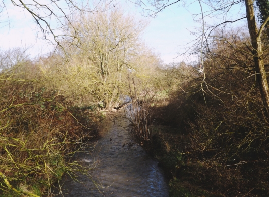
Other watercourses in the area included tributaries to the River Rea including The Bourn, which formed the ancient parish boundary between Kings Norton and Northfield, as well as smaller streams such as Cotteridge Brook and a stream originating near Bullys Farm.
The Birmingham and Worcester Canal, which marks the boundary between Stirchley and Cotteridge, was built in about 1796.
A notable feature is the Ozier plantation, located next to the Rea, in the present day location of Cartland Road. Here willow trees would have been grown for basket making, among other things.
By 1838 the following roads were already in existence:
| Present Day Name | Tithe Map Name (1838) | Other Names |
| Bournville Lane | Road | |
| Dads Lane | Dads Lane | |
| Edwin Road | Foredrove | |
| Elm Tree Road |
Foredrove (to Ivy House Farm)
|
|
| Fordhouse Lane |
part of Black Lane?
|
|
| Hazelwell Fordrough |
Foredrove (to Hazelwell Hall)
|
|
| Pershore Road (between Umberslade Road and Hunts Road) | New Road | |
| Pershore Road | Turnpike Road |
In 1838 the following roads existed but in the present day are no longer in existence:
- Bully Lane, which lead to Bully Farm, near the present day location of the junction of Vicarage Road and Cartland Road
Stirchley Street
A small settlement, known as Stirchley Street is shown on the map at this time, based around the junction of Bournville Lane and Pershore Road. The short straight section of road which cuts the corner of Pershore Road (now Hazelwell Street) was at this time known as ‘New Road’ suggesting it was more recent.
In 1838 the nucleus of Stirchley Street consisted of around twenty houses, a blacksmiths, a chapel and two public houses. The most northerly of these was the Three Horse Shoes Inn which stood near the location of the current day pub of the same name. It was owned by William Congreve Russell (one of the largest landowners at this time) and was tenanted by James Woodcock.
The second pub was the Black Horse Beerhouse, which stood on the corner of Pershore Road and Bournville Lane. This was owned and occupied by Joseph Roston who also owned the large Strutley Meadow to the north.
The chapel was a Wesleyan Chapel possibly built in 1838/9. – located on the junction of Pershore Street and the New Road.
Aside from the settlement of Stirchley Street there was a number of mills, farms and estates located in the area.

Hazelwell Mill
Hazelwell Mill (and mill pond) which was established in the 17th century as a corn mill. By the time of the 1838 the mill was owned by William Deakin who were sword cutters and gun makers. The mill was later used for making rubber, until it’s closure in the 1960’s/70’s. The mill and mill pool is now the site of Stirchley Industrial Estate, built in 1979.
Two further mills were nearby – Dogpool Mill, on the western bank of the Rea, just outside of the Kings Norton boundary to the north of Stirchley and Lifford Mill located south of the railway.
The Hazelwell Estate
Hazelwell Mill is thought to take its name from the name of the family who occupied the manor on the east bank of the Rea from the 13th century onwards. The manor house here was Hazelwell Hall, originally a timber structure and rebuilt after severe damage during the English Civil War. Over time the status of the manor declined and by 1838 the house had been relegated to the status of a farmhouse. At this time it was owned and occupied by Charles Huskisson whose estate stretched from the river up to the railway. On the other side of the road, now known as The Fordrough, was Hazelwell Farm and cottages
Hazelwell Hall survived until the 1930s when it was demolished to make way for housing. The Hazelwell pub was built near to the site of the original hall.
The present day Hazelwell Park used to form part of the Hazelwell Hall estate and the hedgerows, old claypit (now BMX track) and green lane are all depicted the 1830 map. Some of the willow trees in the north of the park near the river could possibly be survivors or descendants from the osier plantation shown on the map.

Ford House Farm
To the south of the Hazelwell Estate, on the other side of Fordhouse Lane stood Ford House Farm belonging to the late William Anderton, who was one of the larger landowners in Kings Norton. The farm at this time was tenanted by Joseph Marshall.
Bullies Farm
To the north of the Hazelwell Estate was Bullies Farm and cottages, which was owned by the Dean and Chapter of Worcester and tenanted to Joseph Moss Todd. This land was later split by the construction of Cartland Road.
Dads Lane Farm
Other Farm to the north was Dads Lane Farm whose farm house was located at the junction of Dads Lane and the present day Pineapple Road.

The Leys Farm
To the west of Pershore Road, bisected by Bournville Lane was The Leys Farm, whose owner is listed in the tithe book as Robert Meers Guest. The farm was tenanted by George Cotterill.
Ivy House Farm
Finally, to the south of this estate was Ivy House Farm, which was owned and occupied by John Haye Twigg who died in 1853 and is buried in Saint Nicolas Churchyard, Kings Norton.
Further Reading
There is a Stirchley Local History Group who meet regularly.
Other Parts of Kings Norton Parish:
Brandwood End | Cotteridge | Kings Heath | Haunch Heath
For more information on the history of Stirchey see William Dargue’s excellent website here

Love local history. More please
LikeLike